You are here: Home > Network List > TA - USArray Transportable Network (new EarthScope stations) Stations List
> Station H05A Madras, OR, USA > Earthquake Result Viewer
H05A Madras, OR, USA - Earthquake Result Viewer
| Earthquake location: |
Southeast Of Loyalty Islands |
| Earthquake latitude/longitude: |
-21.1/169.3 |
| Earthquake time(UTC): |
2007/09/27 (270) 19:57:44 GMT |
| Earthquake Depth: |
9.0 km |
| Earthquake Magnitude: |
6.2 MB, 6.3 MS, 6.1 MW, 6.1 MW |
| Earthquake Catalog/Contributor: |
WHDF/NEIC |
|
| Network: |
TA USArray Transportable Network (new EarthScope stations) |
| Station: |
H05A Madras, OR, USA |
| Lat/Lon: |
44.65 N/121.23 W |
| Elevation: |
721 m |
|
| Distance: |
91.0 deg |
| Az: |
41.963 deg |
| Baz: |
241.007 deg |
| Ray Param: |
0.041634645 |
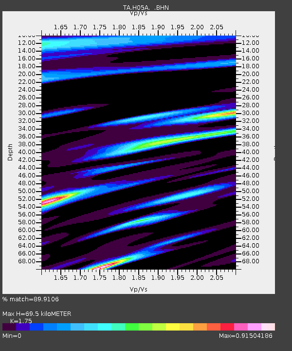
| Estimated Moho Depth: |
69.5 km |
| Estimated Crust Vp/Vs: |
1.75 |
| Assumed Crust Vp: |
6.597 km/s |
| Estimated Crust Vs: |
3.77 km/s |
| Estimated Crust Poisson's Ratio: |
0.26 |
|
| Radial Match: |
89.9106 % |
| Radial Bump: |
400 |
| Transverse Match: |
75.779205 % |
| Transverse Bump: |
400 |
| SOD ConfigId: |
2564 |
| Insert Time: |
2010-03-06 03:43:04.759 +0000 |
| GWidth: |
2.5 |
| Max Bumps: |
400 |
| Tol: |
0.001 |
|
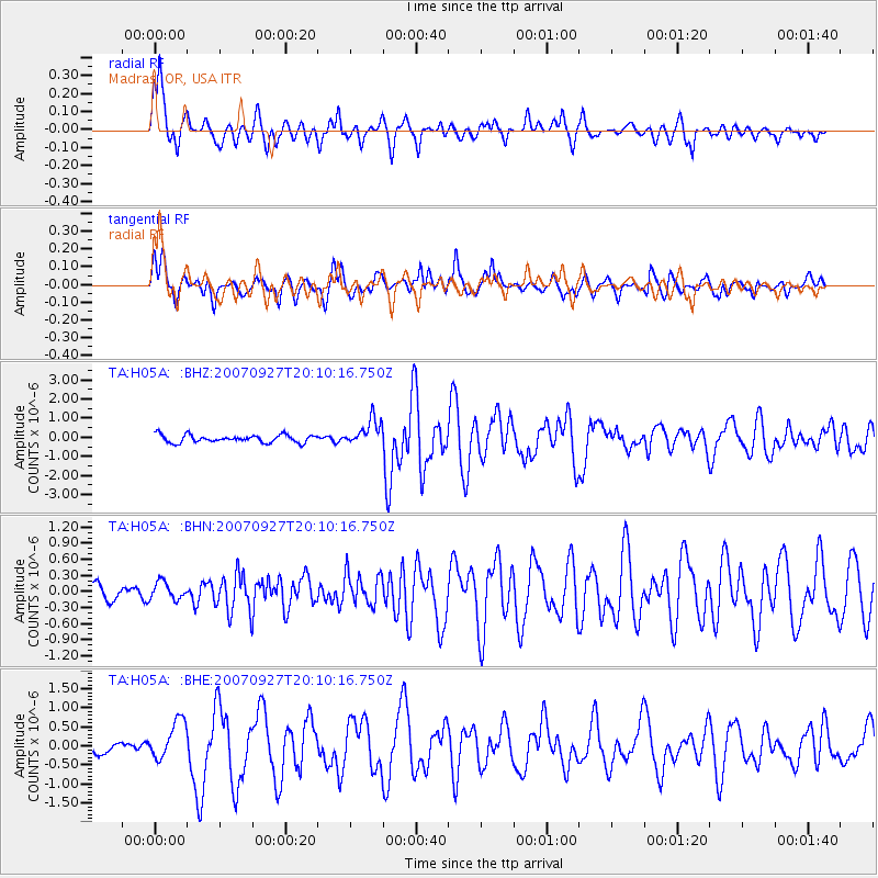
Signal To Noise
| Channel | StoN | STA | LTA |
| TA:H05A: :BHN:20070927T20:10:16.750Z | 0.8980456 | 1.6120828E-7 | 1.7951012E-7 |
| TA:H05A: :BHE:20070927T20:10:16.750Z | 2.1998796 | 5.119279E-7 | 2.3270724E-7 |
| TA:H05A: :BHZ:20070927T20:10:16.750Z | 3.433328 | 6.783404E-7 | 1.9757519E-7 |
| Arrivals |
| Ps | 8.1 SECOND |
| PpPs | 28 SECOND |
| PsPs/PpSs | 36 SECOND |


