You are here: Home > Network List > TA - USArray Transportable Network (new EarthScope stations) Stations List
> Station H05A Madras, OR, USA > Earthquake Result Viewer
H05A Madras, OR, USA - Earthquake Result Viewer
| Earthquake location: |
Santa Cruz Islands |
| Earthquake latitude/longitude: |
-11.6/165.8 |
| Earthquake time(UTC): |
2007/09/02 (245) 01:05:18 GMT |
| Earthquake Depth: |
35 km |
| Earthquake Magnitude: |
5.9 MB, 7.3 MS, 7.2 MW, 6.9 ME |
| Earthquake Catalog/Contributor: |
WHDF/NEIC |
|
| Network: |
TA USArray Transportable Network (new EarthScope stations) |
| Station: |
H05A Madras, OR, USA |
| Lat/Lon: |
44.65 N/121.23 W |
| Elevation: |
721 m |
|
| Distance: |
86.3 deg |
| Az: |
43.162 deg |
| Baz: |
249.883 deg |
| Ray Param: |
0.044095237 |
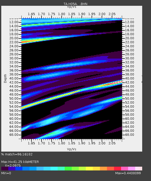
| Estimated Moho Depth: |
41.25 km |
| Estimated Crust Vp/Vs: |
2.10 |
| Assumed Crust Vp: |
6.597 km/s |
| Estimated Crust Vs: |
3.145 km/s |
| Estimated Crust Poisson's Ratio: |
0.35 |
|
| Radial Match: |
96.16182 % |
| Radial Bump: |
253 |
| Transverse Match: |
87.869064 % |
| Transverse Bump: |
400 |
| SOD ConfigId: |
2564 |
| Insert Time: |
2010-03-06 03:43:11.462 +0000 |
| GWidth: |
2.5 |
| Max Bumps: |
400 |
| Tol: |
0.001 |
|

Signal To Noise
| Channel | StoN | STA | LTA |
| TA:H05A: :BHN:20070902T01:17:25.275Z | 1.2156445 | 1.5910537E-7 | 1.308815E-7 |
| TA:H05A: :BHE:20070902T01:17:25.275Z | 6.725781 | 1.1621123E-6 | 1.7278474E-7 |
| TA:H05A: :BHZ:20070902T01:17:25.275Z | 22.18792 | 2.7308652E-6 | 1.2307892E-7 |
| Arrivals |
| Ps | 7.0 SECOND |
| PpPs | 19 SECOND |
| PsPs/PpSs | 26 SECOND |


