You are here: Home > Network List > TA - USArray Transportable Network (new EarthScope stations) Stations List
> Station H05A Madras, OR, USA > Earthquake Result Viewer
H05A Madras, OR, USA - Earthquake Result Viewer

| Earthquake location: |
Jujuy Province, Argentina |
| Earthquake latitude/longitude: |
-22.2/-65.8 |
| Earthquake time(UTC): |
2007/07/21 (202) 15:34:52 GMT |
| Earthquake Depth: |
290 km |
| Earthquake Magnitude: |
5.8 MB, 6.4 MW, 6.3 MW |
| Earthquake Catalog/Contributor: |
WHDF/NEIC |
|
| Network: |
TA USArray Transportable Network (new EarthScope stations) |
| Station: |
H05A Madras, OR, USA |
| Lat/Lon: |
44.65 N/121.23 W |
| Elevation: |
721 m |
|
| Distance: |
83.5 deg |
| Az: |
323.723 deg |
| Baz: |
129.784 deg |
| Ray Param: |
0.045390286 |
| Estimated Moho Depth: |
38.0 km |
| Estimated Crust Vp/Vs: |
1.85 |
| Assumed Crust Vp: |
6.597 km/s |
| Estimated Crust Vs: |
3.571 km/s |
| Estimated Crust Poisson's Ratio: |
0.29 |
|
| Radial Match: |
94.22208 % |
| Radial Bump: |
293 |
| Transverse Match: |
83.946724 % |
| Transverse Bump: |
372 |
| SOD ConfigId: |
2564 |
| Insert Time: |
2010-03-06 03:43:15.060 +0000 |
| GWidth: |
2.5 |
| Max Bumps: |
400 |
| Tol: |
0.001 |
|
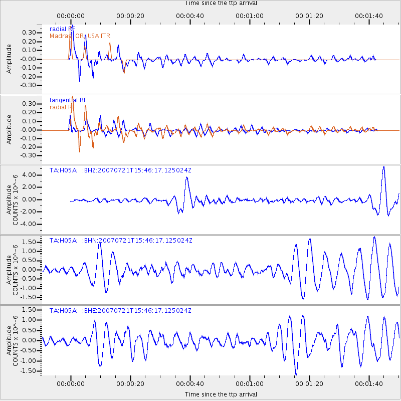
Signal To Noise
| Channel | StoN | STA | LTA |
| TA:H05A: :BHN:20070721T15:46:17.125024Z | 1.7067914 | 1.9776809E-7 | 1.1587127E-7 |
| TA:H05A: :BHE:20070721T15:46:17.125024Z | 0.6812281 | 1.2002722E-7 | 1.761924E-7 |
| TA:H05A: :BHZ:20070721T15:46:17.125024Z | 1.8454927 | 3.342719E-7 | 1.8112881E-7 |
| Arrivals |
| Ps | 5.0 SECOND |
| PpPs | 16 SECOND |
| PsPs/PpSs | 21 SECOND |


