You are here: Home > Network List > TA - USArray Transportable Network (new EarthScope stations) Stations List
> Station H05A Madras, OR, USA > Earthquake Result Viewer
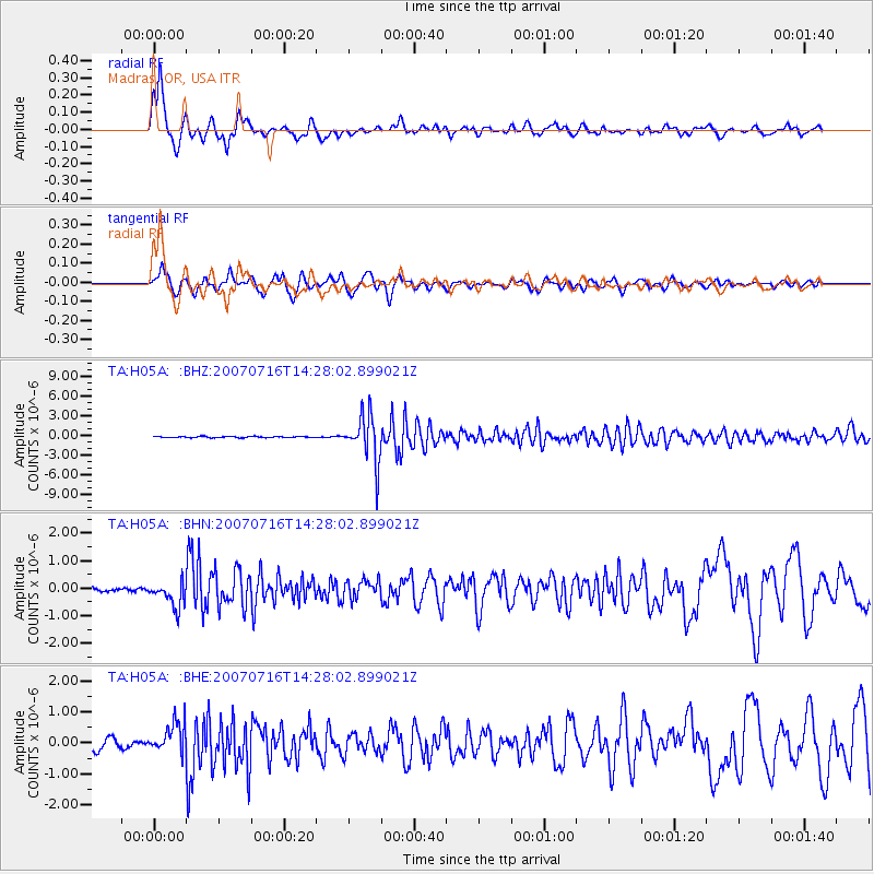
H05A Madras, OR, USA - Earthquake Result Viewer

| Earthquake location: |
Sea Of Japan |
| Earthquake latitude/longitude: |
36.8/134.9 |
| Earthquake time(UTC): |
2007/07/16 (197) 14:17:37 GMT |
| Earthquake Depth: |
350 km |
| Earthquake Magnitude: |
6.2 MB, 6.8 MW, 6.8 MW |
| Earthquake Catalog/Contributor: |
WHDF/NEIC |
|
| Network: |
TA USArray Transportable Network (new EarthScope stations) |
| Station: |
H05A Madras, OR, USA |
| Lat/Lon: |
44.65 N/121.23 W |
| Elevation: |
721 m |
|
| Distance: |
73.7 deg |
| Az: |
46.194 deg |
| Baz: |
305.763 deg |
| Ray Param: |
0.05178114 |
| Estimated Moho Depth: |
12.75 km |
| Estimated Crust Vp/Vs: |
1.60 |
| Assumed Crust Vp: |
6.597 km/s |
| Estimated Crust Vs: |
4.123 km/s |
| Estimated Crust Poisson's Ratio: |
0.18 |
|
| Radial Match: |
85.60602 % |
| Radial Bump: |
367 |
| Transverse Match: |
77.04704 % |
| Transverse Bump: |
400 |
| SOD ConfigId: |
2564 |
| Insert Time: |
2010-03-06 03:43:17.964 +0000 |
| GWidth: |
2.5 |
| Max Bumps: |
400 |
| Tol: |
0.001 |
|
Signal To Noise
| Channel | StoN | STA | LTA |
| TA:H05A: :BHN:20070716T14:28:02.899021Z | 3.5602999 | 4.6530985E-7 | 1.30694E-7 |
| TA:H05A: :BHE:20070716T14:28:02.899021Z | 2.868418 | 4.8456997E-7 | 1.6893283E-7 |
| TA:H05A: :BHZ:20070716T14:28:02.899021Z | 36.90515 | 3.5045668E-6 | 9.496145E-8 |
| Arrivals |
| Ps | 1.2 SECOND |
| PpPs | 4.8 SECOND |
| PsPs/PpSs | 6.0 SECOND |


