You are here: Home > Network List > TA - USArray Transportable Network (new EarthScope stations) Stations List
> Station H05A Madras, OR, USA > Earthquake Result Viewer
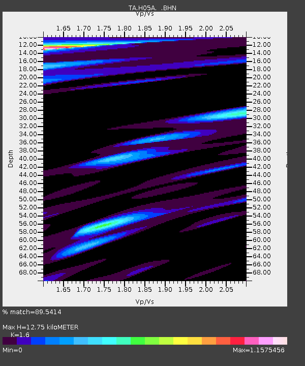
H05A Madras, OR, USA - Earthquake Result Viewer
| Earthquake location: |
Mariana Islands |
| Earthquake latitude/longitude: |
21.0/144.7 |
| Earthquake time(UTC): |
2007/01/30 (030) 21:37:45 GMT |
| Earthquake Depth: |
30 km |
| Earthquake Magnitude: |
6.3 MB, 6.5 MS, 6.6 MW, 6.5 MW |
| Earthquake Catalog/Contributor: |
WHDF/NEIC |
|
| Network: |
TA USArray Transportable Network (new EarthScope stations) |
| Station: |
H05A Madras, OR, USA |
| Lat/Lon: |
44.65 N/121.23 W |
| Elevation: |
721 m |
|
| Distance: |
78.4 deg |
| Az: |
46.633 deg |
| Baz: |
287.878 deg |
| Ray Param: |
0.049661472 |
| Estimated Moho Depth: |
12.75 km |
| Estimated Crust Vp/Vs: |
1.60 |
| Assumed Crust Vp: |
6.597 km/s |
| Estimated Crust Vs: |
4.123 km/s |
| Estimated Crust Poisson's Ratio: |
0.18 |
|
| Radial Match: |
89.5414 % |
| Radial Bump: |
383 |
| Transverse Match: |
72.6918 % |
| Transverse Bump: |
400 |
| SOD ConfigId: |
2564 |
| Insert Time: |
2010-03-06 03:43:35.395 +0000 |
| GWidth: |
2.5 |
| Max Bumps: |
400 |
| Tol: |
0.001 |
|

Signal To Noise
| Channel | StoN | STA | LTA |
| TA:H05A: :BHN:20070130T21:49:12.10002Z | 0.92585504 | 3.8221387E-7 | 4.1282257E-7 |
| TA:H05A: :BHE:20070130T21:49:12.10002Z | 1.1323628 | 5.2975815E-7 | 4.6783427E-7 |
| TA:H05A: :BHZ:20070130T21:49:12.10002Z | 8.356992 | 2.285468E-6 | 2.7347977E-7 |
| Arrivals |
| Ps | 1.2 SECOND |
| PpPs | 4.9 SECOND |
| PsPs/PpSs | 6.1 SECOND |


