You are here: Home > Network List > TA - USArray Transportable Network (new EarthScope stations) Stations List
> Station H05A Madras, OR, USA > Earthquake Result Viewer
H05A Madras, OR, USA - Earthquake Result Viewer
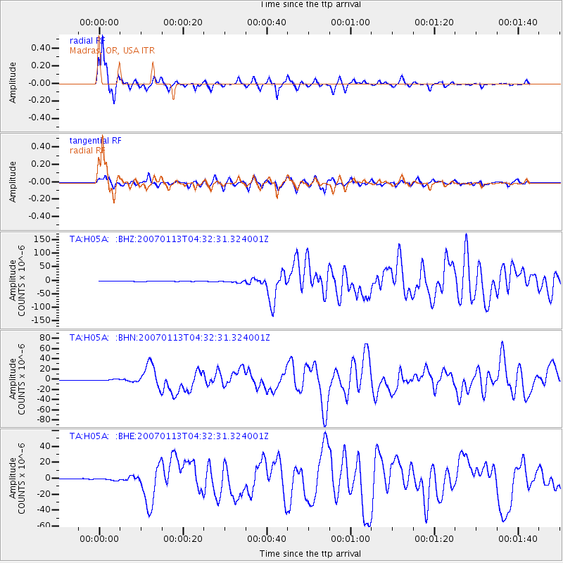
| Earthquake location: |
East Of Kuril Islands |
| Earthquake latitude/longitude: |
46.2/154.5 |
| Earthquake time(UTC): |
2007/01/13 (013) 04:23:21 GMT |
| Earthquake Depth: |
10 km |
| Earthquake Magnitude: |
7.3 MB, 8.2 MS, 8.1 MW, 7.9 MW |
| Earthquake Catalog/Contributor: |
WHDF/NEIC |
|
| Network: |
TA USArray Transportable Network (new EarthScope stations) |
| Station: |
H05A Madras, OR, USA |
| Lat/Lon: |
44.65 N/121.23 W |
| Elevation: |
721 m |
|
| Distance: |
56.4 deg |
| Az: |
58.539 deg |
| Baz: |
303.968 deg |
| Ray Param: |
0.06418774 |
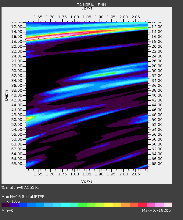
| Estimated Moho Depth: |
16.5 km |
| Estimated Crust Vp/Vs: |
1.65 |
| Assumed Crust Vp: |
6.597 km/s |
| Estimated Crust Vs: |
3.998 km/s |
| Estimated Crust Poisson's Ratio: |
0.21 |
|
| Radial Match: |
97.55591 % |
| Radial Bump: |
263 |
| Transverse Match: |
93.491875 % |
| Transverse Bump: |
392 |
| SOD ConfigId: |
2564 |
| Insert Time: |
2010-03-06 03:43:37.242 +0000 |
| GWidth: |
2.5 |
| Max Bumps: |
400 |
| Tol: |
0.001 |
|
Signal To Noise
| Channel | StoN | STA | LTA |
| TA:H05A: :BHN:20070113T04:32:31.324001Z | 3.7749174 | 1.2322798E-6 | 3.2643888E-7 |
| TA:H05A: :BHE:20070113T04:32:31.324001Z | 5.229662 | 1.3302664E-6 | 2.5436947E-7 |
| TA:H05A: :BHZ:20070113T04:32:31.324001Z | 13.122567 | 3.150321E-6 | 2.4006894E-7 |
| Arrivals |
| Ps | 1.7 SECOND |
| PpPs | 6.3 SECOND |
| PsPs/PpSs | 8.0 SECOND |


