You are here: Home > Network List > TA - USArray Transportable Network (new EarthScope stations) Stations List
> Station H05A Madras, OR, USA > Earthquake Result Viewer
H05A Madras, OR, USA - Earthquake Result Viewer
| Earthquake location: |
Fiji Islands Region |
| Earthquake latitude/longitude: |
-19.9/-178.2 |
| Earthquake time(UTC): |
2006/01/02 (002) 22:13:40 GMT |
| Earthquake Depth: |
583 km |
| Earthquake Magnitude: |
6.5 MB, 7.2 MW, 7.1 MW |
| Earthquake Catalog/Contributor: |
WHDF/NEIC |
|
| Network: |
TA USArray Transportable Network (new EarthScope stations) |
| Station: |
H05A Madras, OR, USA |
| Lat/Lon: |
44.65 N/121.23 W |
| Elevation: |
721 m |
|
| Distance: |
82.6 deg |
| Az: |
37.11 deg |
| Baz: |
232.682 deg |
| Ray Param: |
0.045040734 |
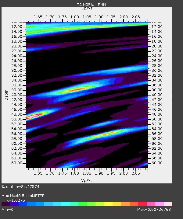
| Estimated Moho Depth: |
48.5 km |
| Estimated Crust Vp/Vs: |
1.63 |
| Assumed Crust Vp: |
6.597 km/s |
| Estimated Crust Vs: |
4.054 km/s |
| Estimated Crust Poisson's Ratio: |
0.20 |
|
| Radial Match: |
84.47574 % |
| Radial Bump: |
387 |
| Transverse Match: |
78.01045 % |
| Transverse Bump: |
360 |
| SOD ConfigId: |
5423 |
| Insert Time: |
2010-03-06 03:43:39.065 +0000 |
| GWidth: |
2.5 |
| Max Bumps: |
400 |
| Tol: |
0.001 |
|
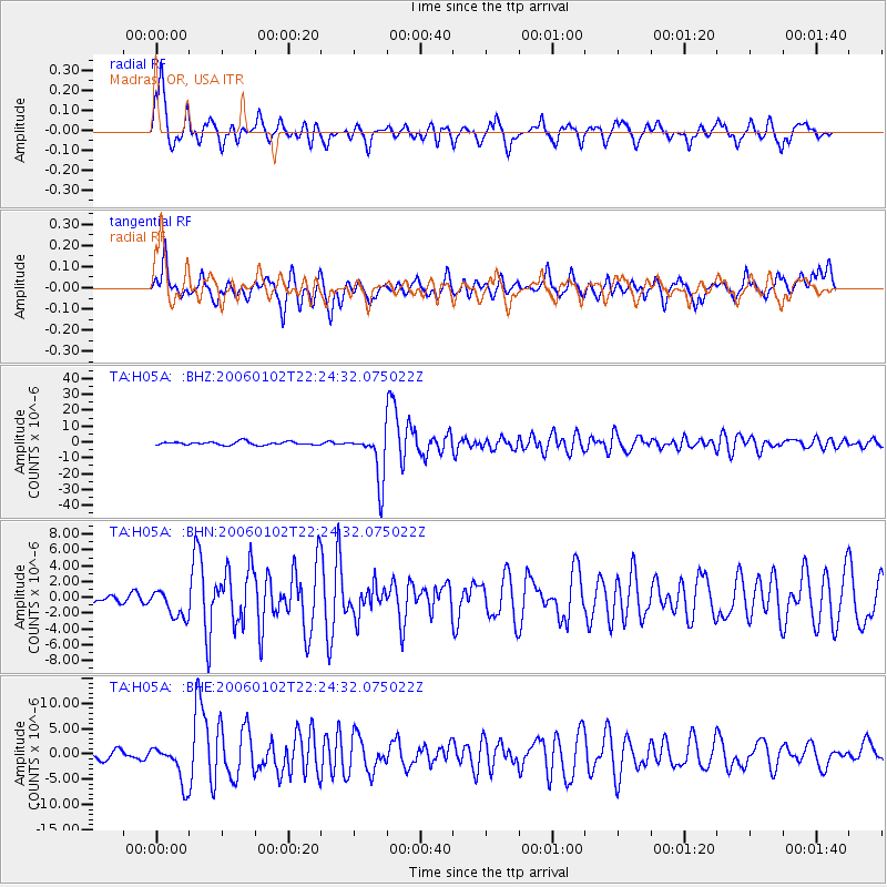
Signal To Noise
| Channel | StoN | STA | LTA |
| TA:H05A: :BHN:20060102T22:24:32.075022Z | 1.4958531 | 1.7771325E-6 | 1.1880395E-6 |
| TA:H05A: :BHE:20060102T22:24:32.075022Z | 3.5663755 | 3.8122785E-6 | 1.0689504E-6 |
| TA:H05A: :BHZ:20060102T22:24:32.075022Z | 15.288704 | 1.558061E-5 | 1.0190929E-6 |
| Arrivals |
| Ps | 4.7 SECOND |
| PpPs | 19 SECOND |
| PsPs/PpSs | 24 SECOND |


