You are here: Home > Network List > TA - USArray Transportable Network (new EarthScope stations) Stations List
> Station H05A Madras, OR, USA > Earthquake Result Viewer
H05A Madras, OR, USA - Earthquake Result Viewer
| Earthquake location: |
Kuril Islands |
| Earthquake latitude/longitude: |
46.5/153.2 |
| Earthquake time(UTC): |
2006/10/01 (274) 09:06:02 GMT |
| Earthquake Depth: |
19 km |
| Earthquake Magnitude: |
6.1 MB, 6.4 MS, 6.6 MW, 6.5 MW |
| Earthquake Catalog/Contributor: |
WHDF/NEIC |
|
| Network: |
TA USArray Transportable Network (new EarthScope stations) |
| Station: |
H05A Madras, OR, USA |
| Lat/Lon: |
44.65 N/121.23 W |
| Elevation: |
721 m |
|
| Distance: |
57.0 deg |
| Az: |
58.047 deg |
| Baz: |
304.758 deg |
| Ray Param: |
0.06374885 |
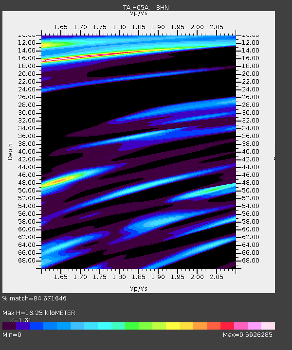
| Estimated Moho Depth: |
16.25 km |
| Estimated Crust Vp/Vs: |
1.61 |
| Assumed Crust Vp: |
6.597 km/s |
| Estimated Crust Vs: |
4.098 km/s |
| Estimated Crust Poisson's Ratio: |
0.19 |
|
| Radial Match: |
84.671646 % |
| Radial Bump: |
255 |
| Transverse Match: |
79.54179 % |
| Transverse Bump: |
343 |
| SOD ConfigId: |
2665 |
| Insert Time: |
2010-03-06 03:43:42.258 +0000 |
| GWidth: |
2.5 |
| Max Bumps: |
400 |
| Tol: |
0.001 |
|
Signal To Noise
| Channel | StoN | STA | LTA |
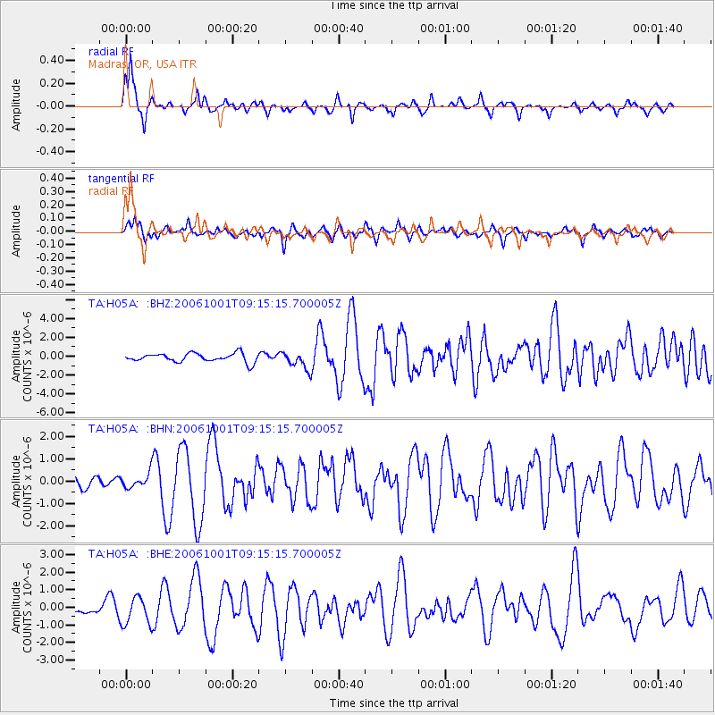
| TA:H05A: :BHN:20061001T09:15:15.700005Z | 0.67008597 | 3.2142896E-7 | 4.7968314E-7 |
| TA:H05A: :BHE:20061001T09:15:15.700005Z | 1.3904854 | 7.808174E-7 | 5.6154306E-7 |
| TA:H05A: :BHZ:20061001T09:15:15.700005Z | 2.0409262 | 9.519292E-7 | 4.664202E-7 |
| Arrivals |
| Ps | 1.6 SECOND |
| PpPs | 6.1 SECOND |
| PsPs/PpSs | 7.7 SECOND |


