You are here: Home > Network List > TA - USArray Transportable Network (new EarthScope stations) Stations List
> Station H05A Madras, OR, USA > Earthquake Result Viewer
H05A Madras, OR, USA - Earthquake Result Viewer
| Earthquake location: |
Near East Coast Of Kamchatka |
| Earthquake latitude/longitude: |
51.1/157.5 |
| Earthquake time(UTC): |
2006/08/24 (236) 21:50:36 GMT |
| Earthquake Depth: |
43 km |
| Earthquake Magnitude: |
5.9 MB, 6.2 MS, 6.5 MW, 6.5 MW |
| Earthquake Catalog/Contributor: |
WHDF/NEIC |
|
| Network: |
TA USArray Transportable Network (new EarthScope stations) |
| Station: |
H05A Madras, OR, USA |
| Lat/Lon: |
44.65 N/121.23 W |
| Elevation: |
721 m |
|
| Distance: |
52.2 deg |
| Az: |
63.173 deg |
| Baz: |
308.054 deg |
| Ray Param: |
0.066789895 |
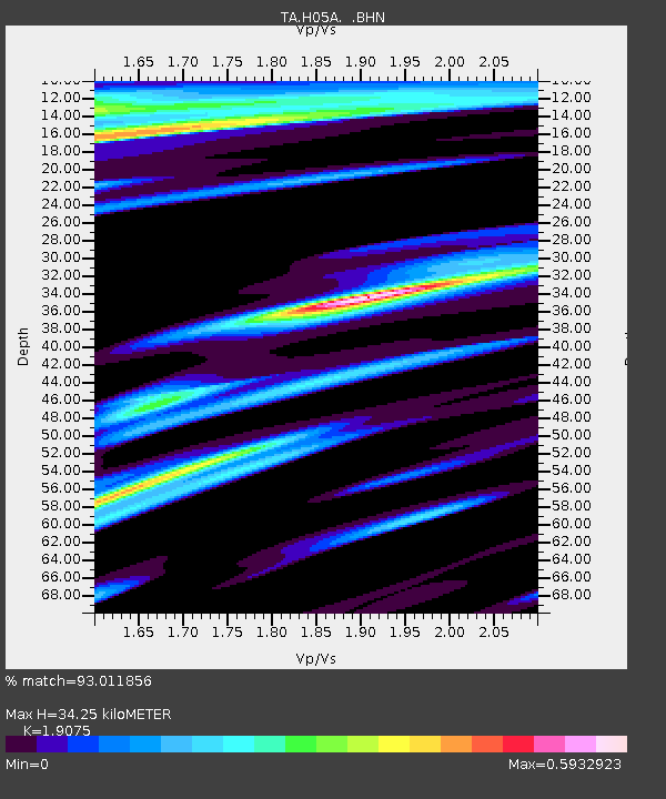
| Estimated Moho Depth: |
34.25 km |
| Estimated Crust Vp/Vs: |
1.91 |
| Assumed Crust Vp: |
6.597 km/s |
| Estimated Crust Vs: |
3.459 km/s |
| Estimated Crust Poisson's Ratio: |
0.31 |
|
| Radial Match: |
93.011856 % |
| Radial Bump: |
334 |
| Transverse Match: |
86.28684 % |
| Transverse Bump: |
400 |
| SOD ConfigId: |
2665 |
| Insert Time: |
2010-03-06 03:43:51.419 +0000 |
| GWidth: |
2.5 |
| Max Bumps: |
400 |
| Tol: |
0.001 |
|
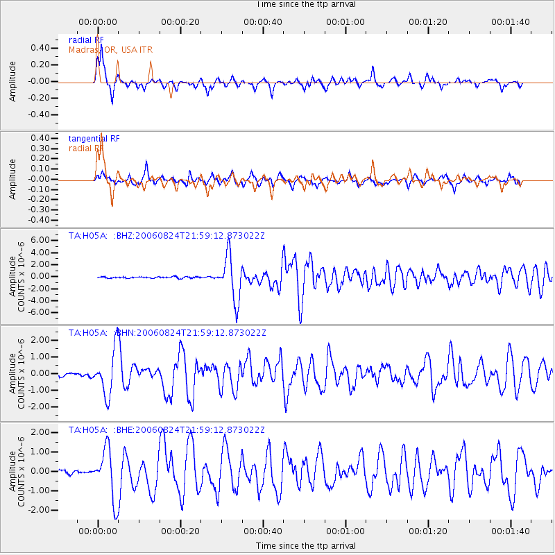
Signal To Noise
| Channel | StoN | STA | LTA |
| TA:H05A: :BHN:20060824T21:59:12.873022Z | 9.646489 | 1.4113946E-6 | 1.4631172E-7 |
| TA:H05A: :BHE:20060824T21:59:12.873022Z | 16.572126 | 1.3486035E-6 | 8.137782E-8 |
| TA:H05A: :BHZ:20060824T21:59:12.873022Z | 33.571503 | 3.8107912E-6 | 1.1351268E-7 |
| Arrivals |
| Ps | 5.0 SECOND |
| PpPs | 14 SECOND |
| PsPs/PpSs | 19 SECOND |


