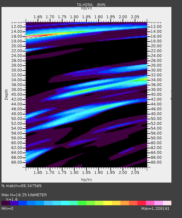
H05A Madras, OR, USA - Earthquake Result Viewer
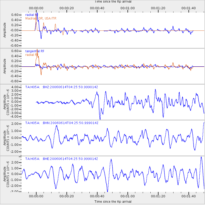
Earthquake location: Rat Islands, Aleutian Islands
Earthquake latitude/longitude: 51.8/177.1
Earthquake time(UTC): 2006/06/14 (165) 04:18:42 GMT
Earthquake Depth: 14 km
Earthquake Magnitude: 5.9 MB, 6.4 MS, 6.4 MW, 6.4 MW
Earthquake Catalog/Contributor: WHDF/NEIC
Network: TA USArray Transportable Network (new EarthScope stations)
Station: H05A Madras, OR, USA
Lat/Lon: 44.65 N/121.23 W
Elevation: 721 m
Distance: 40.6 deg
Az: 74.846 deg
Baz: 302.798 deg
Ray Param: 0.07428336
Estimated Moho Depth: 16.25 km
Estimated Crust Vp/Vs: 1.60
Assumed Crust Vp: 6.597 km/s
Estimated Crust Vs: 4.123 km/s
Estimated Crust Poisson's Ratio: 0.18
Radial Match: 89.347565 %
Radial Bump: 319
Transverse Match: 69.854546 %
Transverse Bump: 400
SOD ConfigId: 5745
Insert Time: 2010-03-06 03:44:02.918 +0000
GWidth: 2.5
Max Bumps: 400
Tol: 0.001

Signal To Noise

ChannelStoNSTALTA
TA:H05A: :BHN:20060614T04:25:50.999014Z1.03950612.431301E-72.3389E-7
TA:H05A: :BHE:20060614T04:25:50.999014Z1.02284053.3379112E-73.2633739E-7
TA:H05A: :BHZ:20060614T04:25:50.999014Z2.55959655.092425E-71.9895423E-7
Arrivals
Ps1.6 SECOND
PpPs5.9 SECOND
PsPs/PpSs7.5 SECOND