You are here: Home > Network List > TA - USArray Transportable Network (new EarthScope stations) Stations List
> Station D25K Kavik River, AK, USA > Earthquake Result Viewer
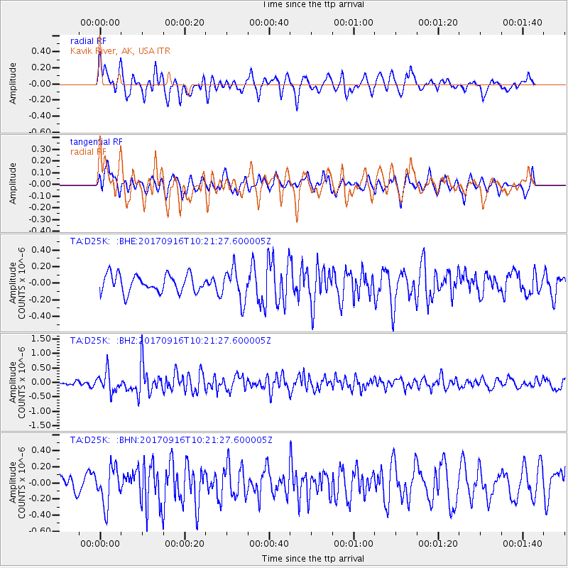
D25K Kavik River, AK, USA - Earthquake Result Viewer
*The percent match for this event was below the threshold and hence no stack was calculated.
| Earthquake location: |
Northern Xinjiang, China |
| Earthquake latitude/longitude: |
42.2/83.5 |
| Earthquake time(UTC): |
2017/09/16 (259) 10:11:33 GMT |
| Earthquake Depth: |
16 km |
| Earthquake Magnitude: |
5.4 Mww |
| Earthquake Catalog/Contributor: |
NEIC PDE/us |
|
| Network: |
TA USArray Transportable Network (new EarthScope stations) |
| Station: |
D25K Kavik River, AK, USA |
| Lat/Lon: |
69.32 N/146.38 W |
| Elevation: |
770 m |
|
| Distance: |
62.9 deg |
| Az: |
17.769 deg |
| Baz: |
320.33 deg |
| Ray Param: |
$rayparam |
*The percent match for this event was below the threshold and hence was not used in the summary stack. |
|
| Radial Match: |
65.153404 % |
| Radial Bump: |
400 |
| Transverse Match: |
56.683666 % |
| Transverse Bump: |
400 |
| SOD ConfigId: |
13570011 |
| Insert Time: |
2019-04-28 19:06:05.780 +0000 |
| GWidth: |
2.5 |
| Max Bumps: |
400 |
| Tol: |
0.001 |
|
Signal To Noise
| Channel | StoN | STA | LTA |
| TA:D25K: :BHZ:20170916T10:21:27.600005Z | 5.3806605 | 3.4782434E-7 | 6.464342E-8 |
| TA:D25K: :BHN:20170916T10:21:27.600005Z | 1.6674638 | 2.352482E-7 | 1.4108143E-7 |
| TA:D25K: :BHE:20170916T10:21:27.600005Z | 1.872548 | 1.9706744E-7 | 1.0524026E-7 |
| Arrivals |
| Ps | |
| PpPs | |
| PsPs/PpSs | |


