You are here: Home > Network List > TA - USArray Transportable Network (new EarthScope stations) Stations List
> Station F21K Alatna River, AK, USA > Earthquake Result Viewer
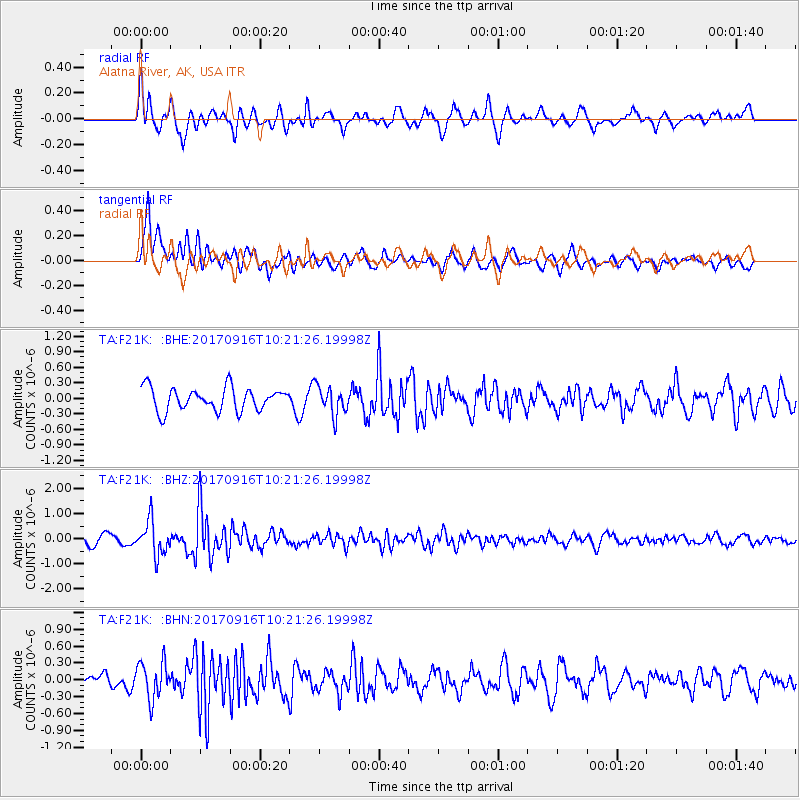
F21K Alatna River, AK, USA - Earthquake Result Viewer
*The percent match for this event was below the threshold and hence no stack was calculated.
| Earthquake location: |
Northern Xinjiang, China |
| Earthquake latitude/longitude: |
42.2/83.5 |
| Earthquake time(UTC): |
2017/09/16 (259) 10:11:33 GMT |
| Earthquake Depth: |
16 km |
| Earthquake Magnitude: |
5.4 Mww |
| Earthquake Catalog/Contributor: |
NEIC PDE/us |
|
| Network: |
TA USArray Transportable Network (new EarthScope stations) |
| Station: |
F21K Alatna River, AK, USA |
| Lat/Lon: |
67.22 N/153.48 W |
| Elevation: |
597 m |
|
| Distance: |
62.7 deg |
| Az: |
21.564 deg |
| Baz: |
315.467 deg |
| Ray Param: |
$rayparam |
*The percent match for this event was below the threshold and hence was not used in the summary stack. |
|
| Radial Match: |
74.76891 % |
| Radial Bump: |
400 |
| Transverse Match: |
73.77475 % |
| Transverse Bump: |
400 |
| SOD ConfigId: |
13570011 |
| Insert Time: |
2019-04-28 19:06:33.015 +0000 |
| GWidth: |
2.5 |
| Max Bumps: |
400 |
| Tol: |
0.001 |
|
Signal To Noise
| Channel | StoN | STA | LTA |
| TA:F21K: :BHZ:20170916T10:21:26.19998Z | 3.1892688 | 6.770871E-7 | 2.1230167E-7 |
| TA:F21K: :BHN:20170916T10:21:26.19998Z | 2.337236 | 3.2729608E-7 | 1.4003552E-7 |
| TA:F21K: :BHE:20170916T10:21:26.19998Z | 1.2711278 | 2.8045042E-7 | 2.2063116E-7 |
| Arrivals |
| Ps | |
| PpPs | |
| PsPs/PpSs | |


