You are here: Home > Network List > TA - USArray Transportable Network (new EarthScope stations) Stations List
> Station G16K Koyuk River, AK, USA > Earthquake Result Viewer
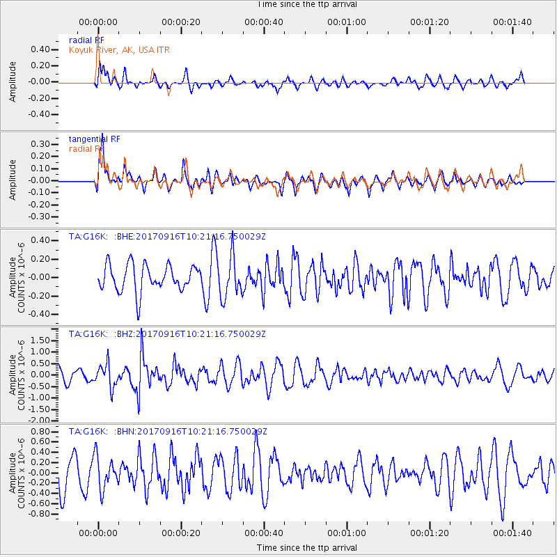
G16K Koyuk River, AK, USA - Earthquake Result Viewer
*The percent match for this event was below the threshold and hence no stack was calculated.
| Earthquake location: |
Northern Xinjiang, China |
| Earthquake latitude/longitude: |
42.2/83.5 |
| Earthquake time(UTC): |
2017/09/16 (259) 10:11:33 GMT |
| Earthquake Depth: |
16 km |
| Earthquake Magnitude: |
5.4 Mww |
| Earthquake Catalog/Contributor: |
NEIC PDE/us |
|
| Network: |
TA USArray Transportable Network (new EarthScope stations) |
| Station: |
G16K Koyuk River, AK, USA |
| Lat/Lon: |
65.39 N/162.35 W |
| Elevation: |
169 m |
|
| Distance: |
61.3 deg |
| Az: |
25.833 deg |
| Baz: |
309.355 deg |
| Ray Param: |
$rayparam |
*The percent match for this event was below the threshold and hence was not used in the summary stack. |
|
| Radial Match: |
54.291603 % |
| Radial Bump: |
400 |
| Transverse Match: |
56.82527 % |
| Transverse Bump: |
400 |
| SOD ConfigId: |
13570011 |
| Insert Time: |
2019-04-28 19:06:40.493 +0000 |
| GWidth: |
2.5 |
| Max Bumps: |
400 |
| Tol: |
0.001 |
|
Signal To Noise
| Channel | StoN | STA | LTA |
| TA:G16K: :BHZ:20170916T10:21:16.750029Z | 2.1913645 | 5.111767E-7 | 2.3326868E-7 |
| TA:G16K: :BHN:20170916T10:21:16.750029Z | 1.1067582 | 3.1684516E-7 | 2.862822E-7 |
| TA:G16K: :BHE:20170916T10:21:16.750029Z | 1.5600281 | 2.2202177E-7 | 1.4231908E-7 |
| Arrivals |
| Ps | |
| PpPs | |
| PsPs/PpSs | |


