You are here: Home > Network List > TA - USArray Transportable Network (new EarthScope stations) Stations List
> Station G22K Bettles, AK, USA > Earthquake Result Viewer
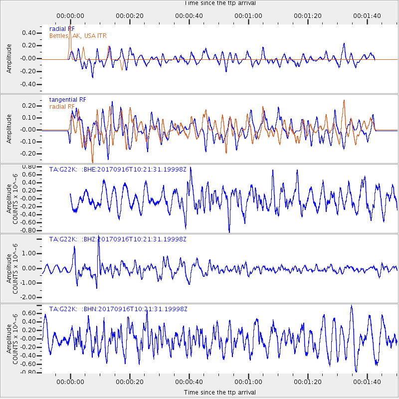
G22K Bettles, AK, USA - Earthquake Result Viewer
*The percent match for this event was below the threshold and hence no stack was calculated.
| Earthquake location: |
Northern Xinjiang, China |
| Earthquake latitude/longitude: |
42.2/83.5 |
| Earthquake time(UTC): |
2017/09/16 (259) 10:11:33 GMT |
| Earthquake Depth: |
16 km |
| Earthquake Magnitude: |
5.4 Mww |
| Earthquake Catalog/Contributor: |
NEIC PDE/us |
|
| Network: |
TA USArray Transportable Network (new EarthScope stations) |
| Station: |
G22K Bettles, AK, USA |
| Lat/Lon: |
66.92 N/151.51 W |
| Elevation: |
205 m |
|
| Distance: |
63.4 deg |
| Az: |
21.171 deg |
| Baz: |
317.107 deg |
| Ray Param: |
$rayparam |
*The percent match for this event was below the threshold and hence was not used in the summary stack. |
|
| Radial Match: |
60.486015 % |
| Radial Bump: |
400 |
| Transverse Match: |
55.73775 % |
| Transverse Bump: |
400 |
| SOD ConfigId: |
13570011 |
| Insert Time: |
2019-04-28 19:06:42.983 +0000 |
| GWidth: |
2.5 |
| Max Bumps: |
400 |
| Tol: |
0.001 |
|
Signal To Noise
| Channel | StoN | STA | LTA |
| TA:G22K: :BHZ:20170916T10:21:31.19998Z | 3.3989744 | 5.789549E-7 | 1.7033223E-7 |
| TA:G22K: :BHN:20170916T10:21:31.19998Z | 0.81815165 | 1.7036497E-7 | 2.0823153E-7 |
| TA:G22K: :BHE:20170916T10:21:31.19998Z | 0.8348898 | 1.8139956E-7 | 2.1727365E-7 |
| Arrivals |
| Ps | |
| PpPs | |
| PsPs/PpSs | |


