You are here: Home > Network List > UW - Pacific Northwest Regional Seismic Network Stations List
> Station MRBL Marblemount, WA, USA > Earthquake Result Viewer
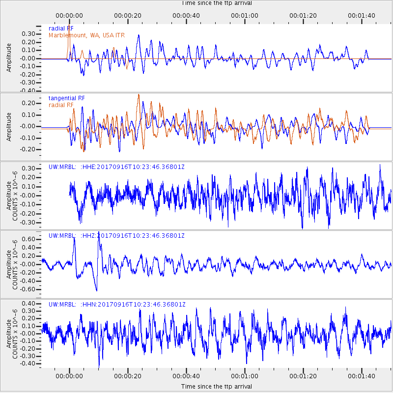
MRBL Marblemount, WA, USA - Earthquake Result Viewer
*The percent match for this event was below the threshold and hence no stack was calculated.
| Earthquake location: |
Northern Xinjiang, China |
| Earthquake latitude/longitude: |
42.2/83.5 |
| Earthquake time(UTC): |
2017/09/16 (259) 10:11:33 GMT |
| Earthquake Depth: |
16 km |
| Earthquake Magnitude: |
5.4 Mww |
| Earthquake Catalog/Contributor: |
NEIC PDE/us |
|
| Network: |
UW Pacific Northwest Regional Seismic Network |
| Station: |
MRBL Marblemount, WA, USA |
| Lat/Lon: |
48.52 N/121.48 W |
| Elevation: |
75 m |
|
| Distance: |
87.0 deg |
| Az: |
16.342 deg |
| Baz: |
341.674 deg |
| Ray Param: |
$rayparam |
*The percent match for this event was below the threshold and hence was not used in the summary stack. |
|
| Radial Match: |
57.017105 % |
| Radial Bump: |
400 |
| Transverse Match: |
62.810272 % |
| Transverse Bump: |
400 |
| SOD ConfigId: |
13570011 |
| Insert Time: |
2019-04-28 19:08:14.514 +0000 |
| GWidth: |
2.5 |
| Max Bumps: |
400 |
| Tol: |
0.001 |
|
Signal To Noise
| Channel | StoN | STA | LTA |
| UW:MRBL: :HHZ:20170916T10:23:46.36801Z | 3.2639883 | 2.4985394E-7 | 7.6548666E-8 |
| UW:MRBL: :HHN:20170916T10:23:46.36801Z | 1.4056627 | 1.2683725E-7 | 9.0233065E-8 |
| UW:MRBL: :HHE:20170916T10:23:46.36801Z | 1.001133 | 8.779178E-8 | 8.769243E-8 |
| Arrivals |
| Ps | |
| PpPs | |
| PsPs/PpSs | |


