You are here: Home > Network List > TA - USArray Transportable Network (new EarthScope stations) Stations List
> Station H08A Prairie City, OR, USA > Earthquake Result Viewer
H08A Prairie City, OR, USA - Earthquake Result Viewer
| Earthquake location: |
Mariana Islands |
| Earthquake latitude/longitude: |
18.9/145.4 |
| Earthquake time(UTC): |
2007/10/31 (304) 03:30:17 GMT |
| Earthquake Depth: |
223 km |
| Earthquake Magnitude: |
6.2 MB, 7.2 MW, 7.2 MW |
| Earthquake Catalog/Contributor: |
WHDF/NEIC |
|
| Network: |
TA USArray Transportable Network (new EarthScope stations) |
| Station: |
H08A Prairie City, OR, USA |
| Lat/Lon: |
44.52 N/118.67 W |
| Elevation: |
1373 m |
|
| Distance: |
81.1 deg |
| Az: |
46.066 deg |
| Baz: |
287.619 deg |
| Ray Param: |
0.047250323 |
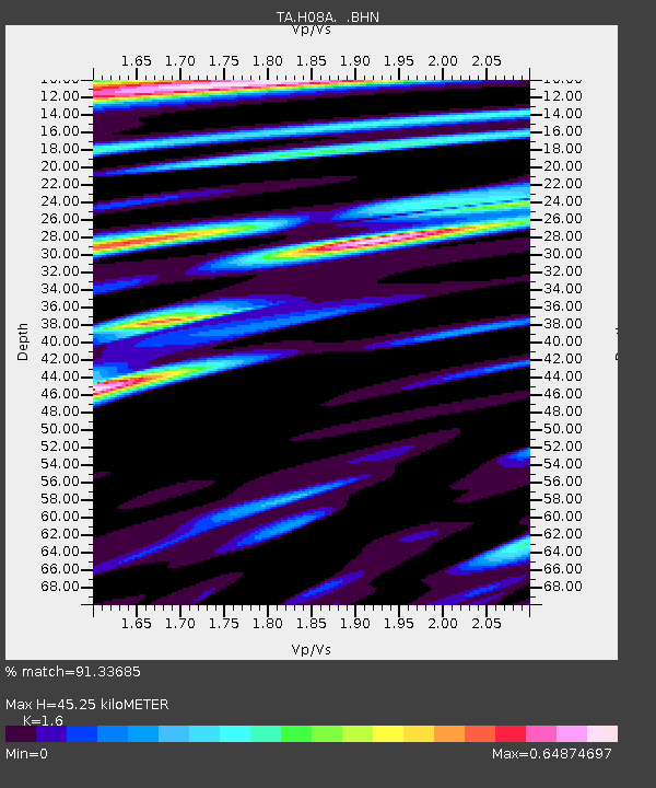
| Estimated Moho Depth: |
45.25 km |
| Estimated Crust Vp/Vs: |
1.60 |
| Assumed Crust Vp: |
6.571 km/s |
| Estimated Crust Vs: |
4.107 km/s |
| Estimated Crust Poisson's Ratio: |
0.18 |
|
| Radial Match: |
91.33685 % |
| Radial Bump: |
400 |
| Transverse Match: |
88.65336 % |
| Transverse Bump: |
400 |
| SOD ConfigId: |
2564 |
| Insert Time: |
2010-03-06 03:45:02.450 +0000 |
| GWidth: |
2.5 |
| Max Bumps: |
400 |
| Tol: |
0.001 |
|

Signal To Noise
| Channel | StoN | STA | LTA |
| TA:H08A: :BHN:20071031T03:41:36.750027Z | 4.5877886 | 5.411387E-7 | 1.1795198E-7 |
| TA:H08A: :BHE:20071031T03:41:36.750027Z | 5.0734606 | 1.3394829E-6 | 2.640176E-7 |
| TA:H08A: :BHZ:20071031T03:41:36.750027Z | 19.661024 | 4.2015013E-6 | 2.1369698E-7 |
| Arrivals |
| Ps | 4.3 SECOND |
| PpPs | 17 SECOND |
| PsPs/PpSs | 22 SECOND |


