You are here: Home > Network List > TA - USArray Transportable Network (new EarthScope stations) Stations List
> Station H08A Prairie City, OR, USA > Earthquake Result Viewer
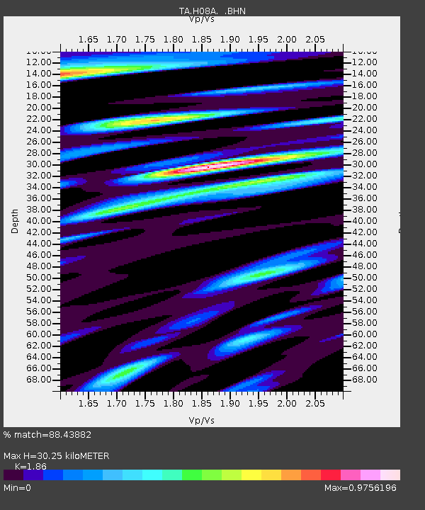
H08A Prairie City, OR, USA - Earthquake Result Viewer
| Earthquake location: |
Near Coast Of Peru |
| Earthquake latitude/longitude: |
-13.6/-76.6 |
| Earthquake time(UTC): |
2007/08/17 (229) 13:18:13 GMT |
| Earthquake Depth: |
48 km |
| Earthquake Magnitude: |
5.6 MB, 5.6 MS, 5.9 MW |
| Earthquake Catalog/Contributor: |
WHDF/NEIC |
|
| Network: |
TA USArray Transportable Network (new EarthScope stations) |
| Station: |
H08A Prairie City, OR, USA |
| Lat/Lon: |
44.52 N/118.67 W |
| Elevation: |
1373 m |
|
| Distance: |
69.3 deg |
| Az: |
329.182 deg |
| Baz: |
135.868 deg |
| Ray Param: |
0.05562337 |
| Estimated Moho Depth: |
30.25 km |
| Estimated Crust Vp/Vs: |
1.86 |
| Assumed Crust Vp: |
6.571 km/s |
| Estimated Crust Vs: |
3.533 km/s |
| Estimated Crust Poisson's Ratio: |
0.30 |
|
| Radial Match: |
88.43882 % |
| Radial Bump: |
400 |
| Transverse Match: |
83.83274 % |
| Transverse Bump: |
400 |
| SOD ConfigId: |
2564 |
| Insert Time: |
2010-03-06 03:45:16.372 +0000 |
| GWidth: |
2.5 |
| Max Bumps: |
400 |
| Tol: |
0.001 |
|

Signal To Noise
| Channel | StoN | STA | LTA |
| TA:H08A: :BHN:20070817T13:28:44.774016Z | 7.913357 | 3.0950466E-7 | 3.911168E-8 |
| TA:H08A: :BHE:20070817T13:28:44.774016Z | 3.451039 | 2.0500778E-7 | 5.9404655E-8 |
| TA:H08A: :BHZ:20070817T13:28:44.774016Z | 11.579621 | 7.3862356E-7 | 6.37865E-8 |
| Arrivals |
| Ps | 4.1 SECOND |
| PpPs | 13 SECOND |
| PsPs/PpSs | 17 SECOND |


