You are here: Home > Network List > TA - USArray Transportable Network (new EarthScope stations) Stations List
> Station H08A Prairie City, OR, USA > Earthquake Result Viewer
H08A Prairie City, OR, USA - Earthquake Result Viewer
| Earthquake location: |
Sea Of Japan |
| Earthquake latitude/longitude: |
36.8/134.9 |
| Earthquake time(UTC): |
2007/07/16 (197) 14:17:37 GMT |
| Earthquake Depth: |
350 km |
| Earthquake Magnitude: |
6.2 MB, 6.8 MW, 6.8 MW |
| Earthquake Catalog/Contributor: |
WHDF/NEIC |
|
| Network: |
TA USArray Transportable Network (new EarthScope stations) |
| Station: |
H08A Prairie City, OR, USA |
| Lat/Lon: |
44.52 N/118.67 W |
| Elevation: |
1373 m |
|
| Distance: |
75.3 deg |
| Az: |
45.173 deg |
| Baz: |
307.279 deg |
| Ray Param: |
0.050764915 |
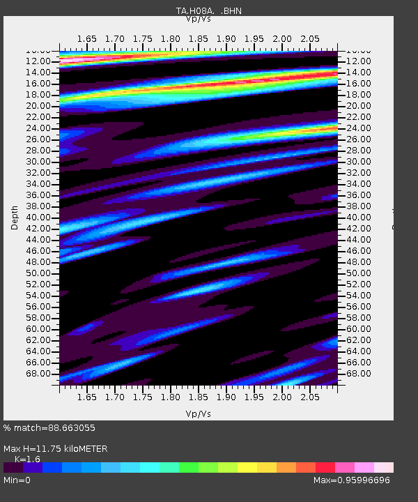
| Estimated Moho Depth: |
11.75 km |
| Estimated Crust Vp/Vs: |
1.60 |
| Assumed Crust Vp: |
6.571 km/s |
| Estimated Crust Vs: |
4.107 km/s |
| Estimated Crust Poisson's Ratio: |
0.18 |
|
| Radial Match: |
88.663055 % |
| Radial Bump: |
400 |
| Transverse Match: |
78.10458 % |
| Transverse Bump: |
400 |
| SOD ConfigId: |
2564 |
| Insert Time: |
2010-03-06 03:45:33.760 +0000 |
| GWidth: |
2.5 |
| Max Bumps: |
400 |
| Tol: |
0.001 |
|

Signal To Noise
| Channel | StoN | STA | LTA |
| TA:H08A: :BHN:20070716T14:28:11.675022Z | 14.550937 | 4.1493522E-7 | 2.8516048E-8 |
| TA:H08A: :BHE:20070716T14:28:11.675022Z | 10.833722 | 5.437176E-7 | 5.0187513E-8 |
| TA:H08A: :BHZ:20070716T14:28:11.675022Z | 49.502472 | 2.2176907E-6 | 4.479959E-8 |
| Arrivals |
| Ps | 1.1 SECOND |
| PpPs | 4.5 SECOND |
| PsPs/PpSs | 5.6 SECOND |


