You are here: Home > Network List > LD - Lamont-Doherty Cooperative Seismographic Network Stations List
> Station GEDE Greenville, DE, USA > Earthquake Result Viewer
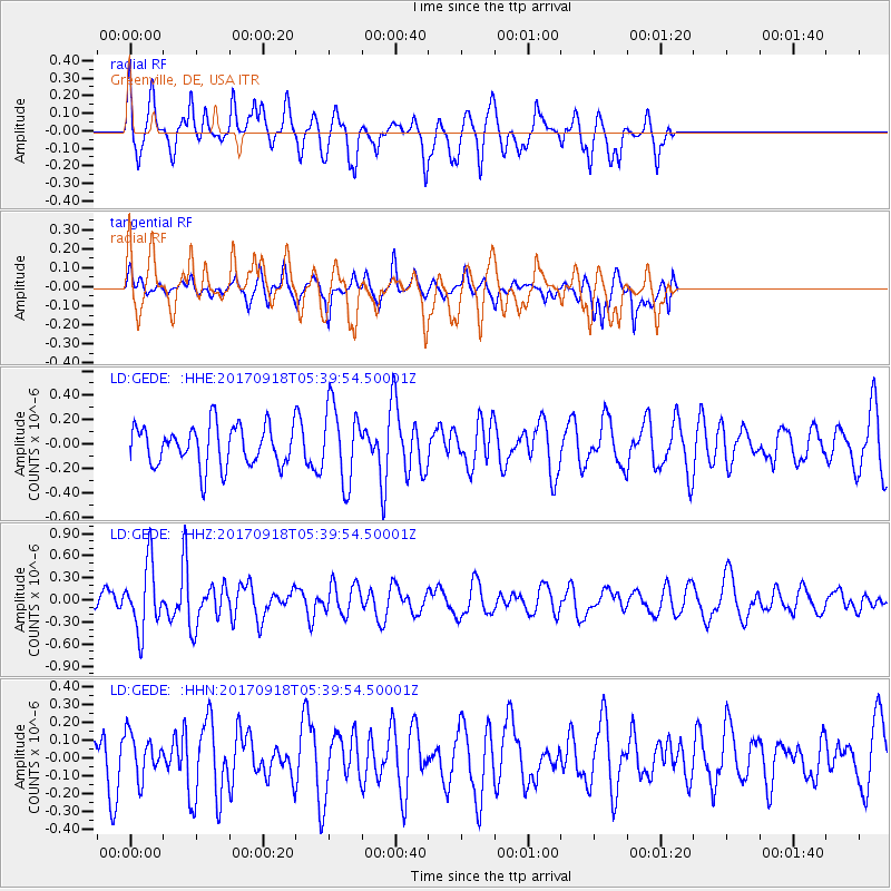
GEDE Greenville, DE, USA - Earthquake Result Viewer
*The percent match for this event was below the threshold and hence no stack was calculated.
| Earthquake location: |
Southern Mid-Atlantic Ridge |
| Earthquake latitude/longitude: |
-18.5/-12.7 |
| Earthquake time(UTC): |
2017/09/18 (261) 05:28:03 GMT |
| Earthquake Depth: |
10 km |
| Earthquake Magnitude: |
5.7 mb |
| Earthquake Catalog/Contributor: |
NEIC PDE/us |
|
| Network: |
LD Lamont-Doherty Cooperative Seismographic Network |
| Station: |
GEDE Greenville, DE, USA |
| Lat/Lon: |
39.81 N/75.64 W |
| Elevation: |
105 m |
|
| Distance: |
82.5 deg |
| Az: |
316.226 deg |
| Baz: |
121.551 deg |
| Ray Param: |
$rayparam |
*The percent match for this event was below the threshold and hence was not used in the summary stack. |
|
| Radial Match: |
71.883675 % |
| Radial Bump: |
400 |
| Transverse Match: |
47.373074 % |
| Transverse Bump: |
262 |
| SOD ConfigId: |
13570011 |
| Insert Time: |
2019-04-28 19:15:52.506 +0000 |
| GWidth: |
2.5 |
| Max Bumps: |
400 |
| Tol: |
0.001 |
|
Signal To Noise
| Channel | StoN | STA | LTA |
| LD:GEDE: :HHZ:20170918T05:39:54.50001Z | 3.767044 | 4.4307185E-7 | 1.1761791E-7 |
| LD:GEDE: :HHN:20170918T05:39:54.50001Z | 1.1842453 | 1.2102976E-7 | 1.02199905E-7 |
| LD:GEDE: :HHE:20170918T05:39:54.50001Z | 1.9126717 | 3.144794E-7 | 1.6441892E-7 |
| Arrivals |
| Ps | |
| PpPs | |
| PsPs/PpSs | |


