You are here: Home > Network List > LD - Lamont-Doherty Cooperative Seismographic Network Stations List
> Station MVL Millersville University, PA > Earthquake Result Viewer
MVL Millersville University, PA - Earthquake Result Viewer
*The percent match for this event was below the threshold and hence no stack was calculated.
| Earthquake location: |
Southern Mid-Atlantic Ridge |
| Earthquake latitude/longitude: |
-18.5/-12.7 |
| Earthquake time(UTC): |
2017/09/18 (261) 05:28:03 GMT |
| Earthquake Depth: |
10 km |
| Earthquake Magnitude: |
5.7 mb |
| Earthquake Catalog/Contributor: |
NEIC PDE/us |
|
| Network: |
LD Lamont-Doherty Cooperative Seismographic Network |
| Station: |
MVL Millersville University, PA |
| Lat/Lon: |
40.00 N/76.35 W |
| Elevation: |
91 m |
|
| Distance: |
83.0 deg |
| Az: |
316.1 deg |
| Baz: |
121.078 deg |
| Ray Param: |
$rayparam |
*The percent match for this event was below the threshold and hence was not used in the summary stack. |
|
| Radial Match: |
46.35206 % |
| Radial Bump: |
390 |
| Transverse Match: |
36.49866 % |
| Transverse Bump: |
398 |
| SOD ConfigId: |
13570011 |
| Insert Time: |
2019-04-28 19:15:56.554 +0000 |
| GWidth: |
2.5 |
| Max Bumps: |
400 |
| Tol: |
0.001 |
|
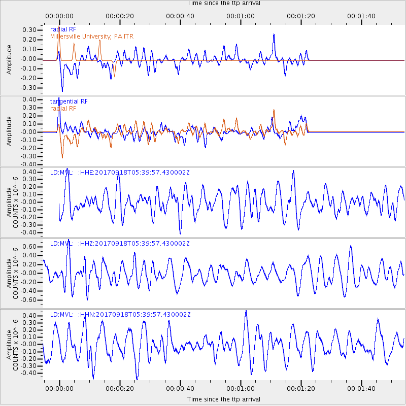
Signal To Noise
| Channel | StoN | STA | LTA |
| LD:MVL: :HHZ:20170918T05:39:57.430002Z | 1.903854 | 3.5010444E-7 | 1.838925E-7 |
| LD:MVL: :HHN:20170918T05:39:57.430002Z | 1.1370184 | 1.714629E-7 | 1.5080046E-7 |
| LD:MVL: :HHE:20170918T05:39:57.430002Z | 0.787754 | 1.2839129E-7 | 1.62984E-7 |
| Arrivals |
| Ps | |
| PpPs | |
| PsPs/PpSs | |


