You are here: Home > Network List > TA - USArray Transportable Network (new EarthScope stations) Stations List
> Station H08A Prairie City, OR, USA > Earthquake Result Viewer
H08A Prairie City, OR, USA - Earthquake Result Viewer
| Earthquake location: |
South Of Panama |
| Earthquake latitude/longitude: |
4.6/-78.5 |
| Earthquake time(UTC): |
2007/03/18 (077) 02:11:05 GMT |
| Earthquake Depth: |
8.0 km |
| Earthquake Magnitude: |
6.4 MB, 5.7 MS, 6.2 MW, 6.1 MW |
| Earthquake Catalog/Contributor: |
WHDF/NEIC |
|
| Network: |
TA USArray Transportable Network (new EarthScope stations) |
| Station: |
H08A Prairie City, OR, USA |
| Lat/Lon: |
44.52 N/118.67 W |
| Elevation: |
1373 m |
|
| Distance: |
53.1 deg |
| Az: |
324.759 deg |
| Baz: |
126.481 deg |
| Ray Param: |
0.0663311 |
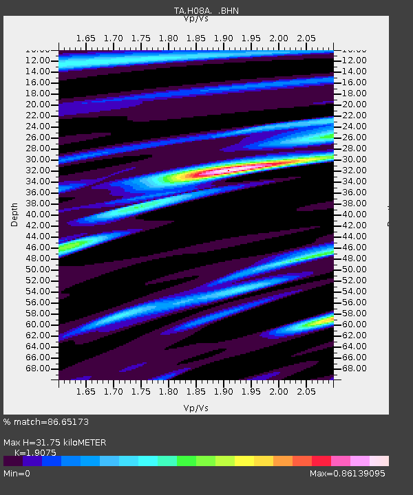
| Estimated Moho Depth: |
31.75 km |
| Estimated Crust Vp/Vs: |
1.91 |
| Assumed Crust Vp: |
6.571 km/s |
| Estimated Crust Vs: |
3.445 km/s |
| Estimated Crust Poisson's Ratio: |
0.31 |
|
| Radial Match: |
86.65173 % |
| Radial Bump: |
400 |
| Transverse Match: |
71.3573 % |
| Transverse Bump: |
400 |
| SOD ConfigId: |
2564 |
| Insert Time: |
2010-03-06 03:45:54.938 +0000 |
| GWidth: |
2.5 |
| Max Bumps: |
400 |
| Tol: |
0.001 |
|

Signal To Noise
| Channel | StoN | STA | LTA |
| TA:H08A: :BHN:20070318T02:19:52.349009Z | 7.746552 | 1.0397089E-6 | 1.342157E-7 |
| TA:H08A: :BHE:20070318T02:19:52.349009Z | 4.7607336 | 9.4456936E-7 | 1.9840836E-7 |
| TA:H08A: :BHZ:20070318T02:19:52.349009Z | 14.195584 | 2.553688E-6 | 1.7989314E-7 |
| Arrivals |
| Ps | 4.6 SECOND |
| PpPs | 13 SECOND |
| PsPs/PpSs | 18 SECOND |


