You are here: Home > Network List > TA - USArray Transportable Network (new EarthScope stations) Stations List
> Station H08A Prairie City, OR, USA > Earthquake Result Viewer
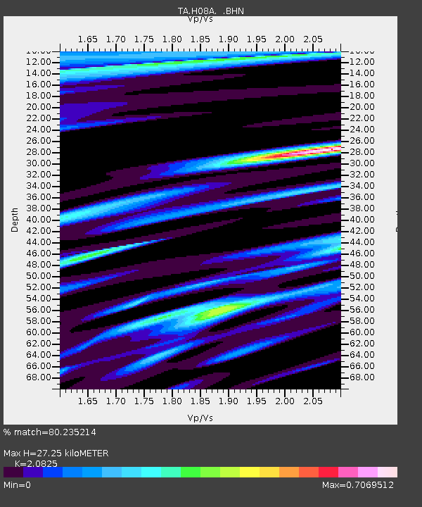
H08A Prairie City, OR, USA - Earthquake Result Viewer
| Earthquake location: |
Near Coast Of Central Chile |
| Earthquake latitude/longitude: |
-31.3/-71.3 |
| Earthquake time(UTC): |
2006/10/12 (285) 18:05:58 GMT |
| Earthquake Depth: |
46 km |
| Earthquake Magnitude: |
5.8 MB, 6.1 MS, 6.4 MW, 6.3 MW |
| Earthquake Catalog/Contributor: |
WHDF/NEIC |
|
| Network: |
TA USArray Transportable Network (new EarthScope stations) |
| Station: |
H08A Prairie City, OR, USA |
| Lat/Lon: |
44.52 N/118.67 W |
| Elevation: |
1373 m |
|
| Distance: |
86.9 deg |
| Az: |
328.208 deg |
| Baz: |
140.92 deg |
| Ray Param: |
0.043623943 |
| Estimated Moho Depth: |
27.25 km |
| Estimated Crust Vp/Vs: |
2.08 |
| Assumed Crust Vp: |
6.571 km/s |
| Estimated Crust Vs: |
3.155 km/s |
| Estimated Crust Poisson's Ratio: |
0.35 |
|
| Radial Match: |
80.235214 % |
| Radial Bump: |
357 |
| Transverse Match: |
67.005516 % |
| Transverse Bump: |
400 |
| SOD ConfigId: |
2665 |
| Insert Time: |
2010-03-06 03:46:12.067 +0000 |
| GWidth: |
2.5 |
| Max Bumps: |
400 |
| Tol: |
0.001 |
|

Signal To Noise
| Channel | StoN | STA | LTA |
| TA:H08A: :BHN:20061012T18:18:07.075022Z | 1.3441653 | 2.1213972E-7 | 1.5782264E-7 |
| TA:H08A: :BHE:20061012T18:18:07.075022Z | 1.3447875 | 2.2210943E-7 | 1.6516321E-7 |
| TA:H08A: :BHZ:20061012T18:18:07.075022Z | 3.2484546 | 5.4412646E-7 | 1.6750317E-7 |
| Arrivals |
| Ps | 4.6 SECOND |
| PpPs | 13 SECOND |
| PsPs/PpSs | 17 SECOND |


