You are here: Home > Network List > TA - USArray Transportable Network (new EarthScope stations) Stations List
> Station H08A Prairie City, OR, USA > Earthquake Result Viewer
H08A Prairie City, OR, USA - Earthquake Result Viewer
| Earthquake location: |
North Atlantic Ocean |
| Earthquake latitude/longitude: |
23.6/-63.9 |
| Earthquake time(UTC): |
2006/07/29 (210) 19:53:43 GMT |
| Earthquake Depth: |
10 km |
| Earthquake Magnitude: |
5.5 MB, 5.0 MS, 5.8 MW, 5.6 MW |
| Earthquake Catalog/Contributor: |
WHDF/NEIC |
|
| Network: |
TA USArray Transportable Network (new EarthScope stations) |
| Station: |
H08A Prairie City, OR, USA |
| Lat/Lon: |
44.52 N/118.67 W |
| Elevation: |
1373 m |
|
| Distance: |
48.9 deg |
| Az: |
309.218 deg |
| Baz: |
96.499 deg |
| Ray Param: |
0.06902635 |
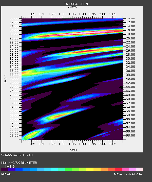
| Estimated Moho Depth: |
17.0 km |
| Estimated Crust Vp/Vs: |
1.90 |
| Assumed Crust Vp: |
6.571 km/s |
| Estimated Crust Vs: |
3.458 km/s |
| Estimated Crust Poisson's Ratio: |
0.31 |
|
| Radial Match: |
89.40748 % |
| Radial Bump: |
400 |
| Transverse Match: |
81.01517 % |
| Transverse Bump: |
400 |
| SOD ConfigId: |
2665 |
| Insert Time: |
2010-03-06 03:46:39.802 +0000 |
| GWidth: |
2.5 |
| Max Bumps: |
400 |
| Tol: |
0.001 |
|
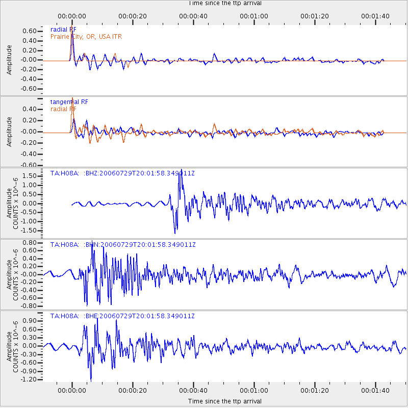
Signal To Noise
| Channel | StoN | STA | LTA |
| TA:H08A: :BHN:20060729T20:01:58.349011Z | 3.2460063 | 1.9023264E-7 | 5.8605135E-8 |
| TA:H08A: :BHE:20060729T20:01:58.349011Z | 3.7860475 | 2.8551827E-7 | 7.541328E-8 |
| TA:H08A: :BHZ:20060729T20:01:58.349011Z | 9.039866 | 5.919506E-7 | 6.5482226E-8 |
| Arrivals |
| Ps | 2.5 SECOND |
| PpPs | 7.1 SECOND |
| PsPs/PpSs | 9.5 SECOND |


