You are here: Home > Network List > IW - Intermountain West Stations List
> Station DLMT Dillon, Montana, USA > Earthquake Result Viewer
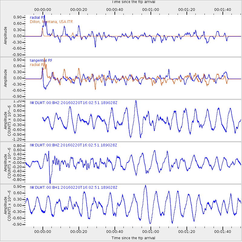
DLMT Dillon, Montana, USA - Earthquake Result Viewer
*The percent match for this event was below the threshold and hence no stack was calculated.
| Earthquake location: |
Fiji Islands Region |
| Earthquake latitude/longitude: |
-21.9/-179.4 |
| Earthquake time(UTC): |
2016/02/20 (051) 15:51:22 GMT |
| Earthquake Depth: |
579 km |
| Earthquake Magnitude: |
5.8 MB |
| Earthquake Catalog/Contributor: |
NEIC PDE/NEIC COMCAT |
|
| Network: |
IW Intermountain West |
| Station: |
DLMT Dillon, Montana, USA |
| Lat/Lon: |
45.36 N/112.60 W |
| Elevation: |
1569 m |
|
| Distance: |
90.3 deg |
| Az: |
40.378 deg |
| Baz: |
238.571 deg |
| Ray Param: |
$rayparam |
*The percent match for this event was below the threshold and hence was not used in the summary stack. |
|
| Radial Match: |
70.70139 % |
| Radial Bump: |
400 |
| Transverse Match: |
70.199104 % |
| Transverse Bump: |
400 |
| SOD ConfigId: |
1427151 |
| Insert Time: |
2016-03-05 16:11:47.927 +0000 |
| GWidth: |
2.5 |
| Max Bumps: |
400 |
| Tol: |
0.001 |
|
Signal To Noise
| Channel | StoN | STA | LTA |
| IW:DLMT:00:BHZ:20160220T16:02:51.189028Z | 2.4490507 | 4.2001872E-7 | 1.7150266E-7 |
| IW:DLMT:00:BH1:20160220T16:02:51.189028Z | 0.8830642 | 2.8852037E-7 | 3.2672637E-7 |
| IW:DLMT:00:BH2:20160220T16:02:51.189028Z | 0.53208977 | 1.8249365E-7 | 3.429753E-7 |
| Arrivals |
| Ps | |
| PpPs | |
| PsPs/PpSs | |


