You are here: Home > Network List > US - United States National Seismic Network Stations List
> Station HAWA Hanford, Washington, USA > Earthquake Result Viewer
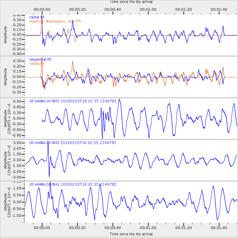
HAWA Hanford, Washington, USA - Earthquake Result Viewer
*The percent match for this event was below the threshold and hence no stack was calculated.
| Earthquake location: |
Fiji Islands Region |
| Earthquake latitude/longitude: |
-21.9/-179.4 |
| Earthquake time(UTC): |
2016/02/20 (051) 15:51:22 GMT |
| Earthquake Depth: |
579 km |
| Earthquake Magnitude: |
5.8 MB |
| Earthquake Catalog/Contributor: |
NEIC PDE/NEIC COMCAT |
|
| Network: |
US United States National Seismic Network |
| Station: |
HAWA Hanford, Washington, USA |
| Lat/Lon: |
46.39 N/119.53 W |
| Elevation: |
364 m |
|
| Distance: |
86.8 deg |
| Az: |
36.818 deg |
| Baz: |
233.515 deg |
| Ray Param: |
$rayparam |
*The percent match for this event was below the threshold and hence was not used in the summary stack. |
|
| Radial Match: |
71.35335 % |
| Radial Bump: |
400 |
| Transverse Match: |
69.50055 % |
| Transverse Bump: |
400 |
| SOD ConfigId: |
1427151 |
| Insert Time: |
2016-03-05 16:13:49.980 +0000 |
| GWidth: |
2.5 |
| Max Bumps: |
400 |
| Tol: |
0.001 |
|
Signal To Noise
| Channel | StoN | STA | LTA |
| US:HAWA:00:BHZ:20160220T16:02:35.224978Z | 2.443886 | 1.1439463E-6 | 4.6808498E-7 |
| US:HAWA:00:BH1:20160220T16:02:35.224978Z | 2.0498295 | 6.704627E-7 | 3.2708218E-7 |
| US:HAWA:00:BH2:20160220T16:02:35.224978Z | 1.309454 | 3.5108272E-7 | 2.681138E-7 |
| Arrivals |
| Ps | |
| PpPs | |
| PsPs/PpSs | |


