You are here: Home > Network List > RV - Regional Alberta Seismic Observatory for Earthquake Studies Network Stations List
> Station HSPGA Hill Springs, AB > Earthquake Result Viewer
HSPGA Hill Springs, AB - Earthquake Result Viewer
| Earthquake location: |
Off Coast Of Central Chile |
| Earthquake latitude/longitude: |
-31.8/-72.1 |
| Earthquake time(UTC): |
2017/09/18 (261) 13:46:56 GMT |
| Earthquake Depth: |
10 km |
| Earthquake Magnitude: |
5.8 Mww |
| Earthquake Catalog/Contributor: |
NEIC PDE/us |
|
| Network: |
RV Regional Alberta Seismic Observatory for Earthquake Studies Network |
| Station: |
HSPGA Hill Springs, AB |
| Lat/Lon: |
49.36 N/113.65 W |
| Elevation: |
1155 m |
|
| Distance: |
88.9 deg |
| Az: |
334.318 deg |
| Baz: |
145.65 deg |
| Ray Param: |
0.04226867 |
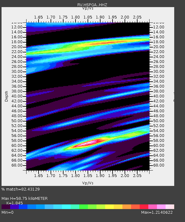
| Estimated Moho Depth: |
58.75 km |
| Estimated Crust Vp/Vs: |
1.85 |
| Assumed Crust Vp: |
6.178 km/s |
| Estimated Crust Vs: |
3.349 km/s |
| Estimated Crust Poisson's Ratio: |
0.29 |
|
| Radial Match: |
82.43129 % |
| Radial Bump: |
400 |
| Transverse Match: |
73.710976 % |
| Transverse Bump: |
400 |
| SOD ConfigId: |
13570011 |
| Insert Time: |
2019-04-28 19:24:56.959 +0000 |
| GWidth: |
2.5 |
| Max Bumps: |
400 |
| Tol: |
0.001 |
|

Signal To Noise
| Channel | StoN | STA | LTA |
| RV:HSPGA: :HHZ:20170918T13:59:19.410007Z | 1.7854532 | 5.641618E-7 | 3.159768E-7 |
| RV:HSPGA: :HHN:20170918T13:59:19.410007Z | 2.4467206 | 6.162105E-7 | 2.5185162E-7 |
| RV:HSPGA: :HHE:20170918T13:59:19.410007Z | 0.80233777 | 3.888459E-7 | 4.8464113E-7 |
| Arrivals |
| Ps | 8.2 SECOND |
| PpPs | 27 SECOND |
| PsPs/PpSs | 35 SECOND |


