You are here: Home > Network List > TA - USArray Transportable Network (new EarthScope stations) Stations List
> Station I02A Mapleton, OR, USA > Earthquake Result Viewer
I02A Mapleton, OR, USA - Earthquake Result Viewer

| Earthquake location: |
Vanuatu Islands |
| Earthquake latitude/longitude: |
-15.6/167.7 |
| Earthquake time(UTC): |
2007/08/01 (213) 17:08:51 GMT |
| Earthquake Depth: |
120 km |
| Earthquake Magnitude: |
6.2 MB, 7.2 MW, 7.2 MW |
| Earthquake Catalog/Contributor: |
WHDF/NEIC |
|
| Network: |
TA USArray Transportable Network (new EarthScope stations) |
| Station: |
I02A Mapleton, OR, USA |
| Lat/Lon: |
44.00 N/123.83 W |
| Elevation: |
170 m |
|
| Distance: |
86.0 deg |
| Az: |
42.3 deg |
| Baz: |
243.993 deg |
| Ray Param: |
0.04411628 |
| Estimated Moho Depth: |
29.75 km |
| Estimated Crust Vp/Vs: |
2.10 |
| Assumed Crust Vp: |
6.566 km/s |
| Estimated Crust Vs: |
3.13 km/s |
| Estimated Crust Poisson's Ratio: |
0.35 |
|
| Radial Match: |
95.367836 % |
| Radial Bump: |
400 |
| Transverse Match: |
87.66279 % |
| Transverse Bump: |
400 |
| SOD ConfigId: |
2564 |
| Insert Time: |
2010-03-06 03:48:08.404 +0000 |
| GWidth: |
2.5 |
| Max Bumps: |
400 |
| Tol: |
0.001 |
|
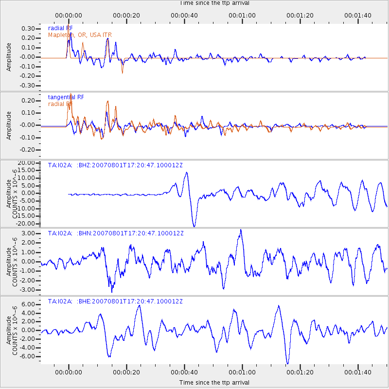
Signal To Noise
| Channel | StoN | STA | LTA |
| TA:I02A: :BHN:20070801T17:20:47.100012Z | 0.63875073 | 2.5680944E-7 | 4.0204955E-7 |
| TA:I02A: :BHE:20070801T17:20:47.100012Z | 1.2082818 | 3.6221223E-7 | 2.9977465E-7 |
| TA:I02A: :BHZ:20070801T17:20:47.100012Z | 3.3282866 | 8.7552183E-7 | 2.6305483E-7 |
| Arrivals |
| Ps | 5.1 SECOND |
| PpPs | 14 SECOND |
| PsPs/PpSs | 19 SECOND |


