You are here: Home > Network List > TA - USArray Transportable Network (new EarthScope stations) Stations List
> Station I02A Mapleton, OR, USA > Earthquake Result Viewer
I02A Mapleton, OR, USA - Earthquake Result Viewer
| Earthquake location: |
Sea Of Japan |
| Earthquake latitude/longitude: |
36.8/134.9 |
| Earthquake time(UTC): |
2007/07/16 (197) 14:17:37 GMT |
| Earthquake Depth: |
350 km |
| Earthquake Magnitude: |
6.2 MB, 6.8 MW, 6.8 MW |
| Earthquake Catalog/Contributor: |
WHDF/NEIC |
|
| Network: |
TA USArray Transportable Network (new EarthScope stations) |
| Station: |
I02A Mapleton, OR, USA |
| Lat/Lon: |
44.00 N/123.83 W |
| Elevation: |
170 m |
|
| Distance: |
72.6 deg |
| Az: |
47.866 deg |
| Baz: |
304.435 deg |
| Ray Param: |
0.052532975 |
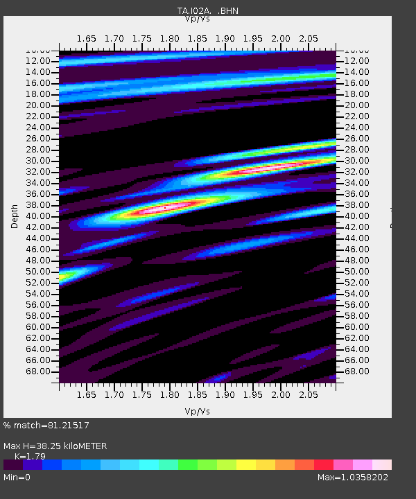
| Estimated Moho Depth: |
38.25 km |
| Estimated Crust Vp/Vs: |
1.79 |
| Assumed Crust Vp: |
6.566 km/s |
| Estimated Crust Vs: |
3.668 km/s |
| Estimated Crust Poisson's Ratio: |
0.27 |
|
| Radial Match: |
81.21517 % |
| Radial Bump: |
400 |
| Transverse Match: |
74.31615 % |
| Transverse Bump: |
400 |
| SOD ConfigId: |
2564 |
| Insert Time: |
2010-03-06 03:48:10.056 +0000 |
| GWidth: |
2.5 |
| Max Bumps: |
400 |
| Tol: |
0.001 |
|

Signal To Noise
| Channel | StoN | STA | LTA |
| TA:I02A: :BHN:20070716T14:27:56.199009Z | 3.2551713 | 4.5527253E-7 | 1.3986131E-7 |
| TA:I02A: :BHE:20070716T14:27:56.199009Z | 5.705152 | 5.0306016E-7 | 8.817647E-8 |
| TA:I02A: :BHZ:20070716T14:27:56.199009Z | 12.89026 | 1.8736552E-6 | 1.4535433E-7 |
| Arrivals |
| Ps | 4.8 SECOND |
| PpPs | 16 SECOND |
| PsPs/PpSs | 20 SECOND |


