You are here: Home > Network List > TA - USArray Transportable Network (new EarthScope stations) Stations List
> Station I02A Mapleton, OR, USA > Earthquake Result Viewer
I02A Mapleton, OR, USA - Earthquake Result Viewer

| Earthquake location: |
Near Coast Of Guatemala |
| Earthquake latitude/longitude: |
13.8/-90.8 |
| Earthquake time(UTC): |
2007/06/08 (159) 13:32:00 GMT |
| Earthquake Depth: |
48 km |
| Earthquake Magnitude: |
5.5 MB, 5.4 MS, 5.8 MW, 5.8 MW |
| Earthquake Catalog/Contributor: |
WHDF/NEIC |
|
| Network: |
TA USArray Transportable Network (new EarthScope stations) |
| Station: |
I02A Mapleton, OR, USA |
| Lat/Lon: |
44.00 N/123.83 W |
| Elevation: |
170 m |
|
| Distance: |
41.2 deg |
| Az: |
323.329 deg |
| Baz: |
126.496 deg |
| Ray Param: |
0.073787935 |
| Estimated Moho Depth: |
13.0 km |
| Estimated Crust Vp/Vs: |
1.87 |
| Assumed Crust Vp: |
6.566 km/s |
| Estimated Crust Vs: |
3.507 km/s |
| Estimated Crust Poisson's Ratio: |
0.30 |
|
| Radial Match: |
80.41641 % |
| Radial Bump: |
400 |
| Transverse Match: |
69.55055 % |
| Transverse Bump: |
400 |
| SOD ConfigId: |
2564 |
| Insert Time: |
2010-03-06 03:48:20.261 +0000 |
| GWidth: |
2.5 |
| Max Bumps: |
400 |
| Tol: |
0.001 |
|
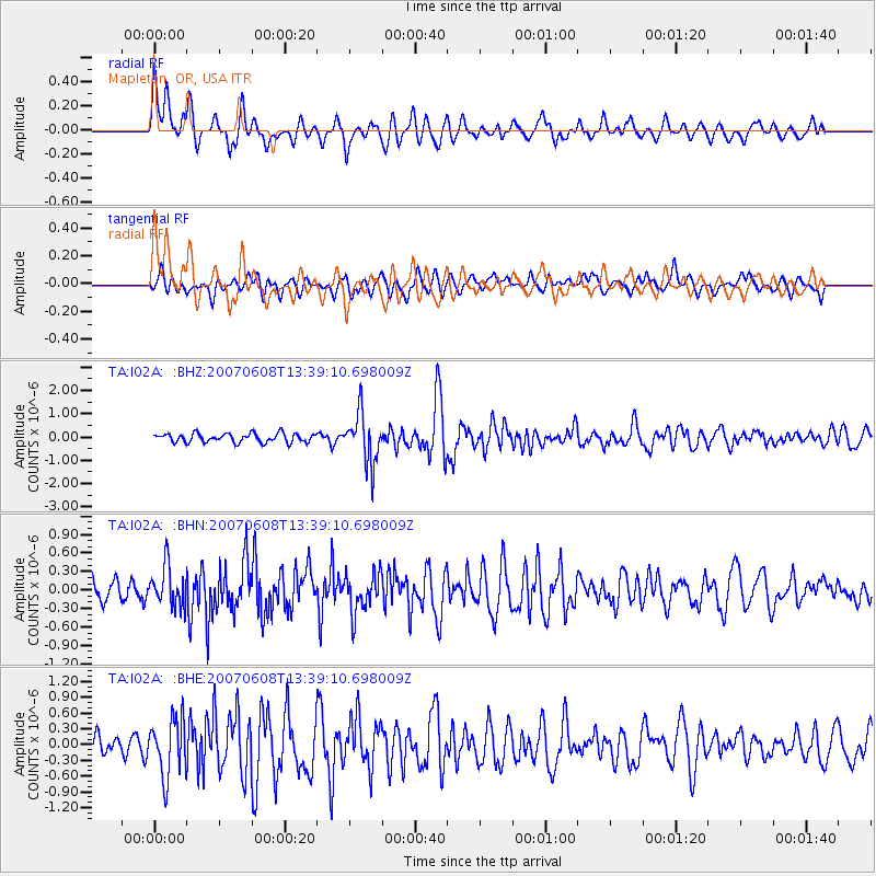
Signal To Noise
| Channel | StoN | STA | LTA |
| TA:I02A: :BHN:20070608T13:39:10.698009Z | 2.3488193 | 3.2202396E-7 | 1.3710036E-7 |
| TA:I02A: :BHE:20070608T13:39:10.698009Z | 3.6677265 | 5.38572E-7 | 1.4684082E-7 |
| TA:I02A: :BHZ:20070608T13:39:10.698009Z | 5.6380124 | 1.0757401E-6 | 1.908013E-7 |
| Arrivals |
| Ps | 1.8 SECOND |
| PpPs | 5.3 SECOND |
| PsPs/PpSs | 7.2 SECOND |


