You are here: Home > Network List > TA - USArray Transportable Network (new EarthScope stations) Stations List
> Station I02A Mapleton, OR, USA > Earthquake Result Viewer
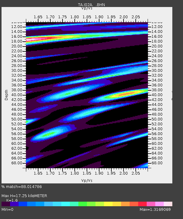
I02A Mapleton, OR, USA - Earthquake Result Viewer
| Earthquake location: |
Kamchatka Peninsula, Russia |
| Earthquake latitude/longitude: |
52.1/157.3 |
| Earthquake time(UTC): |
2007/05/30 (150) 20:22:12 GMT |
| Earthquake Depth: |
116 km |
| Earthquake Magnitude: |
6.4 MB, 6.4 MW, 6.4 MW |
| Earthquake Catalog/Contributor: |
WHDF/NEIC |
|
| Network: |
TA USArray Transportable Network (new EarthScope stations) |
| Station: |
I02A Mapleton, OR, USA |
| Lat/Lon: |
44.00 N/123.83 W |
| Elevation: |
170 m |
|
| Distance: |
50.9 deg |
| Az: |
65.878 deg |
| Baz: |
308.783 deg |
| Ray Param: |
0.06739621 |
| Estimated Moho Depth: |
17.25 km |
| Estimated Crust Vp/Vs: |
1.60 |
| Assumed Crust Vp: |
6.566 km/s |
| Estimated Crust Vs: |
4.104 km/s |
| Estimated Crust Poisson's Ratio: |
0.18 |
|
| Radial Match: |
88.014786 % |
| Radial Bump: |
400 |
| Transverse Match: |
75.93858 % |
| Transverse Bump: |
400 |
| SOD ConfigId: |
2564 |
| Insert Time: |
2010-03-06 03:48:21.638 +0000 |
| GWidth: |
2.5 |
| Max Bumps: |
400 |
| Tol: |
0.001 |
|

Signal To Noise
| Channel | StoN | STA | LTA |
| TA:I02A: :BHN:20070530T20:30:31.200009Z | 6.4812393 | 1.2660988E-6 | 1.9534826E-7 |
| TA:I02A: :BHE:20070530T20:30:31.200009Z | 6.389668 | 1.2706288E-6 | 1.9885677E-7 |
| TA:I02A: :BHZ:20070530T20:30:31.200009Z | 17.471468 | 4.264413E-6 | 2.4407868E-7 |
| Arrivals |
| Ps | 1.7 SECOND |
| PpPs | 6.4 SECOND |
| PsPs/PpSs | 8.1 SECOND |


