You are here: Home > Network List > TA - USArray Transportable Network (new EarthScope stations) Stations List
> Station I02A Mapleton, OR, USA > Earthquake Result Viewer
I02A Mapleton, OR, USA - Earthquake Result Viewer

| Earthquake location: |
Fiji Islands Region |
| Earthquake latitude/longitude: |
-15.3/-178.6 |
| Earthquake time(UTC): |
2005/12/13 (347) 03:16:06 GMT |
| Earthquake Depth: |
10 km |
| Earthquake Magnitude: |
6.1 MB, 6.8 MS, 6.7 MW, 6.7 MW |
| Earthquake Catalog/Contributor: |
WHDF/NEIC |
|
| Network: |
TA USArray Transportable Network (new EarthScope stations) |
| Station: |
I02A Mapleton, OR, USA |
| Lat/Lon: |
44.00 N/123.83 W |
| Elevation: |
170 m |
|
| Distance: |
77.2 deg |
| Az: |
37.169 deg |
| Baz: |
233.908 deg |
| Ray Param: |
0.050459247 |
| Estimated Moho Depth: |
14.75 km |
| Estimated Crust Vp/Vs: |
1.63 |
| Assumed Crust Vp: |
6.566 km/s |
| Estimated Crust Vs: |
4.035 km/s |
| Estimated Crust Poisson's Ratio: |
0.20 |
|
| Radial Match: |
82.5058 % |
| Radial Bump: |
400 |
| Transverse Match: |
79.09111 % |
| Transverse Bump: |
400 |
| SOD ConfigId: |
2564 |
| Insert Time: |
2010-03-06 03:48:30.767 +0000 |
| GWidth: |
2.5 |
| Max Bumps: |
400 |
| Tol: |
0.001 |
|
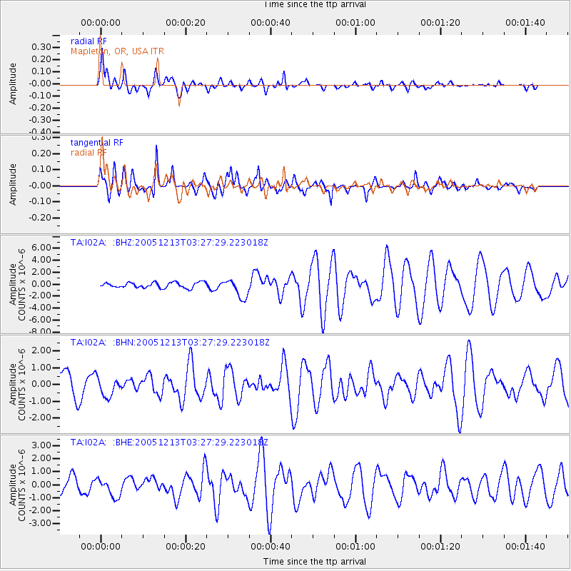
Signal To Noise
| Channel | StoN | STA | LTA |
| TA:I02A: :BHN:20051213T03:27:29.223018Z | 0.8089938 | 5.4113895E-7 | 6.689037E-7 |
| TA:I02A: :BHE:20051213T03:27:29.223018Z | 1.2848356 | 7.03698E-7 | 5.47695E-7 |
| TA:I02A: :BHZ:20051213T03:27:29.223018Z | 3.539717 | 1.5997466E-6 | 4.5194196E-7 |
| Arrivals |
| Ps | 1.5 SECOND |
| PpPs | 5.7 SECOND |
| PsPs/PpSs | 7.2 SECOND |


