You are here: Home > Network List > TA - USArray Transportable Network (new EarthScope stations) Stations List
> Station F21K Alatna River, AK, USA > Earthquake Result Viewer
F21K Alatna River, AK, USA - Earthquake Result Viewer

| Earthquake location: |
Near Coast Of Oaxaca, Mexico |
| Earthquake latitude/longitude: |
15.3/-94.6 |
| Earthquake time(UTC): |
2017/09/18 (261) 14:19:12 GMT |
| Earthquake Depth: |
10 km |
| Earthquake Magnitude: |
5.6 Mww |
| Earthquake Catalog/Contributor: |
NEIC PDE/us |
|
| Network: |
TA USArray Transportable Network (new EarthScope stations) |
| Station: |
F21K Alatna River, AK, USA |
| Lat/Lon: |
67.22 N/153.48 W |
| Elevation: |
597 m |
|
| Distance: |
64.2 deg |
| Az: |
338.264 deg |
| Baz: |
113.361 deg |
| Ray Param: |
0.059057664 |
| Estimated Moho Depth: |
33.25 km |
| Estimated Crust Vp/Vs: |
1.99 |
| Assumed Crust Vp: |
6.455 km/s |
| Estimated Crust Vs: |
3.244 km/s |
| Estimated Crust Poisson's Ratio: |
0.33 |
|
| Radial Match: |
84.444725 % |
| Radial Bump: |
400 |
| Transverse Match: |
67.90927 % |
| Transverse Bump: |
400 |
| SOD ConfigId: |
13570011 |
| Insert Time: |
2019-04-28 19:30:48.709 +0000 |
| GWidth: |
2.5 |
| Max Bumps: |
400 |
| Tol: |
0.001 |
|
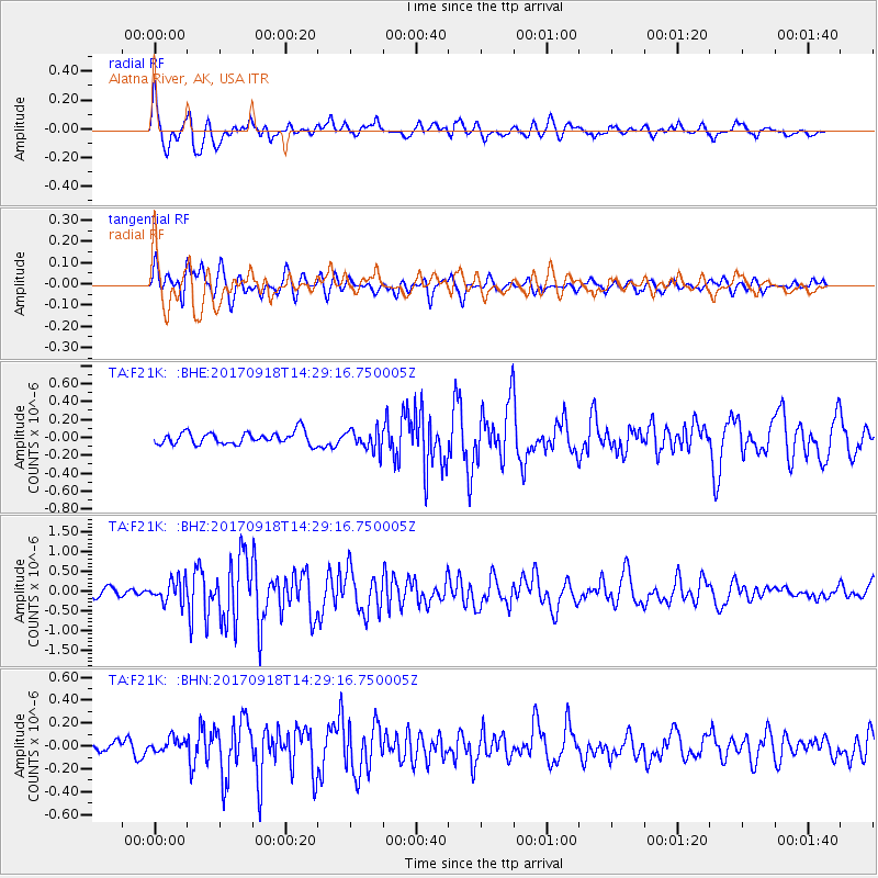
Signal To Noise
| Channel | StoN | STA | LTA |
| TA:F21K: :BHZ:20170918T14:29:16.750005Z | 3.1289067 | 2.803998E-7 | 8.96159E-8 |
| TA:F21K: :BHN:20170918T14:29:16.750005Z | 0.84351546 | 5.888021E-8 | 6.9803356E-8 |
| TA:F21K: :BHE:20170918T14:29:16.750005Z | 1.6187764 | 1.13051335E-7 | 6.983752E-8 |
| Arrivals |
| Ps | 5.3 SECOND |
| PpPs | 15 SECOND |
| PsPs/PpSs | 20 SECOND |


