You are here: Home > Network List > TA - USArray Transportable Network (new EarthScope stations) Stations List
> Station U11A Corn Creek, NV, USA > Earthquake Result Viewer
U11A Corn Creek, NV, USA - Earthquake Result Viewer
| Earthquake location: |
South Of Panama |
| Earthquake latitude/longitude: |
4.6/-78.5 |
| Earthquake time(UTC): |
2007/03/18 (077) 02:11:05 GMT |
| Earthquake Depth: |
8.0 km |
| Earthquake Magnitude: |
6.4 MB, 5.7 MS, 6.2 MW, 6.1 MW |
| Earthquake Catalog/Contributor: |
WHDF/NEIC |
|
| Network: |
TA USArray Transportable Network (new EarthScope stations) |
| Station: |
U11A Corn Creek, NV, USA |
| Lat/Lon: |
36.42 N/115.38 W |
| Elevation: |
867 m |
|
| Distance: |
46.4 deg |
| Az: |
318.024 deg |
| Baz: |
124.248 deg |
| Ray Param: |
0.07069394 |
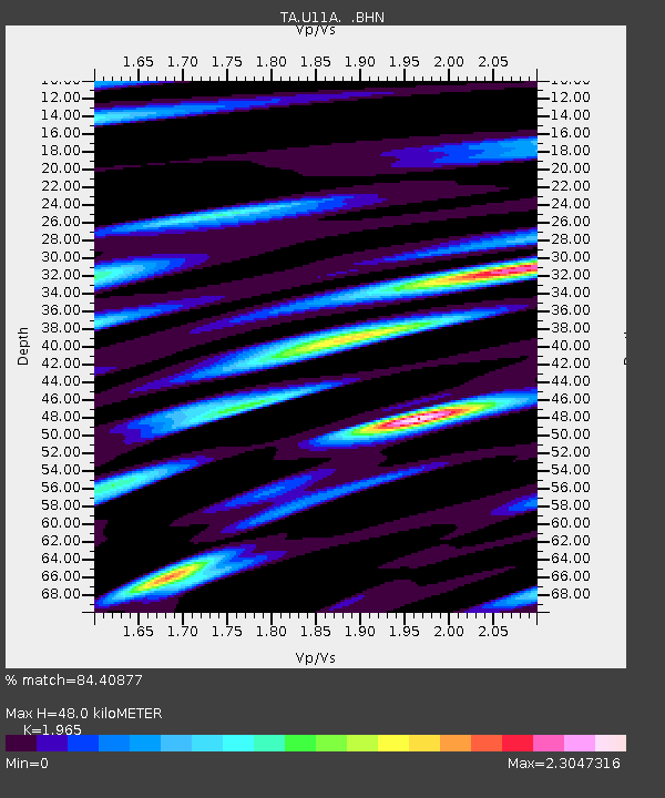
| Estimated Moho Depth: |
48.0 km |
| Estimated Crust Vp/Vs: |
1.97 |
| Assumed Crust Vp: |
6.276 km/s |
| Estimated Crust Vs: |
3.194 km/s |
| Estimated Crust Poisson's Ratio: |
0.33 |
|
| Radial Match: |
84.40877 % |
| Radial Bump: |
400 |
| Transverse Match: |
74.83375 % |
| Transverse Bump: |
400 |
| SOD ConfigId: |
2564 |
| Insert Time: |
2010-03-06 03:49:53.785 +0000 |
| GWidth: |
2.5 |
| Max Bumps: |
400 |
| Tol: |
0.001 |
|
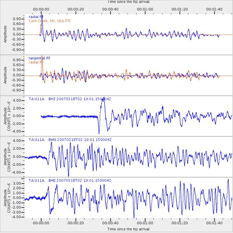
Signal To Noise
| Channel | StoN | STA | LTA |
| TA:U11A: :BHN:20070318T02:19:01.150004Z | 3.4431856 | 6.484749E-7 | 1.8833575E-7 |
| TA:U11A: :BHE:20070318T02:19:01.150004Z | 3.5248609 | 8.575058E-7 | 2.4327366E-7 |
| TA:U11A: :BHZ:20070318T02:19:01.150004Z | 13.4392 | 1.6171247E-6 | 1.2032893E-7 |
| Arrivals |
| Ps | 7.8 SECOND |
| PpPs | 21 SECOND |
| PsPs/PpSs | 29 SECOND |


