You are here: Home > Network List > TA - USArray Transportable Network (new EarthScope stations) Stations List
> Station L15K Ungalak Mountain, AK, USA > Earthquake Result Viewer
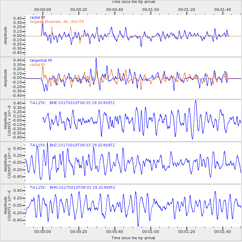
L15K Ungalak Mountain, AK, USA - Earthquake Result Viewer
*The percent match for this event was below the threshold and hence no stack was calculated.
| Earthquake location: |
Near Coast Of Oaxaca, Mexico |
| Earthquake latitude/longitude: |
15.1/-94.1 |
| Earthquake time(UTC): |
2017/09/19 (262) 07:53:13 GMT |
| Earthquake Depth: |
16 km |
| Earthquake Magnitude: |
5.5 Mww |
| Earthquake Catalog/Contributor: |
NEIC PDE/us |
|
| Network: |
TA USArray Transportable Network (new EarthScope stations) |
| Station: |
L15K Ungalak Mountain, AK, USA |
| Lat/Lon: |
61.68 N/161.49 W |
| Elevation: |
219 m |
|
| Distance: |
66.1 deg |
| Az: |
331.214 deg |
| Baz: |
102.777 deg |
| Ray Param: |
$rayparam |
*The percent match for this event was below the threshold and hence was not used in the summary stack. |
|
| Radial Match: |
61.183014 % |
| Radial Bump: |
400 |
| Transverse Match: |
62.821262 % |
| Transverse Bump: |
396 |
| SOD ConfigId: |
13570011 |
| Insert Time: |
2019-04-28 19:36:14.695 +0000 |
| GWidth: |
2.5 |
| Max Bumps: |
400 |
| Tol: |
0.001 |
|
Signal To Noise
| Channel | StoN | STA | LTA |
| TA:L15K: :BHZ:20170919T08:03:28.924995Z | 2.0127494 | 3.14064E-7 | 1.5603732E-7 |
| TA:L15K: :BHN:20170919T08:03:28.924995Z | 1.2566433 | 1.8518568E-7 | 1.4736536E-7 |
| TA:L15K: :BHE:20170919T08:03:28.924995Z | 1.7479324 | 1.6662652E-7 | 9.532778E-8 |
| Arrivals |
| Ps | |
| PpPs | |
| PsPs/PpSs | |


