You are here: Home > Network List > UW - Pacific Northwest Regional Seismic Network Stations List
> Station UMAT Pilot Rock, OR, USA > Earthquake Result Viewer
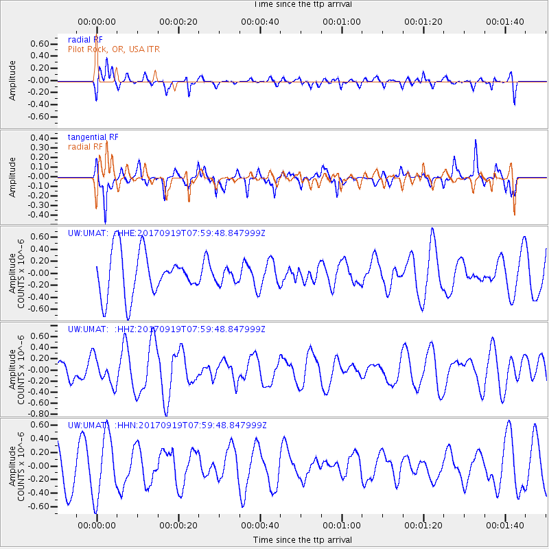
UMAT Pilot Rock, OR, USA - Earthquake Result Viewer
*The percent match for this event was below the threshold and hence no stack was calculated.
| Earthquake location: |
Near Coast Of Oaxaca, Mexico |
| Earthquake latitude/longitude: |
15.1/-94.1 |
| Earthquake time(UTC): |
2017/09/19 (262) 07:53:13 GMT |
| Earthquake Depth: |
16 km |
| Earthquake Magnitude: |
5.5 Mww |
| Earthquake Catalog/Contributor: |
NEIC PDE/us |
|
| Network: |
UW Pacific Northwest Regional Seismic Network |
| Station: |
UMAT Pilot Rock, OR, USA |
| Lat/Lon: |
45.29 N/118.96 W |
| Elevation: |
1318 m |
|
| Distance: |
36.7 deg |
| Az: |
330.161 deg |
| Baz: |
137.095 deg |
| Ray Param: |
$rayparam |
*The percent match for this event was below the threshold and hence was not used in the summary stack. |
|
| Radial Match: |
71.39655 % |
| Radial Bump: |
400 |
| Transverse Match: |
67.477715 % |
| Transverse Bump: |
357 |
| SOD ConfigId: |
13570011 |
| Insert Time: |
2019-04-28 19:36:50.533 +0000 |
| GWidth: |
2.5 |
| Max Bumps: |
400 |
| Tol: |
0.001 |
|
Signal To Noise
| Channel | StoN | STA | LTA |
| UW:UMAT: :HHZ:20170919T07:59:48.847999Z | 0.8062433 | 2.3786816E-7 | 2.9503272E-7 |
| UW:UMAT: :HHN:20170919T07:59:48.847999Z | 1.4758767 | 4.7084183E-7 | 3.190252E-7 |
| UW:UMAT: :HHE:20170919T07:59:48.847999Z | 0.3309936 | 1.2165538E-7 | 3.6754602E-7 |
| Arrivals |
| Ps | |
| PpPs | |
| PsPs/PpSs | |


