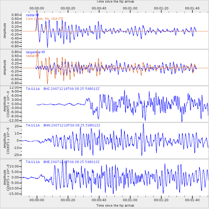
U11A Corn Creek, NV, USA - Earthquake Result Viewer
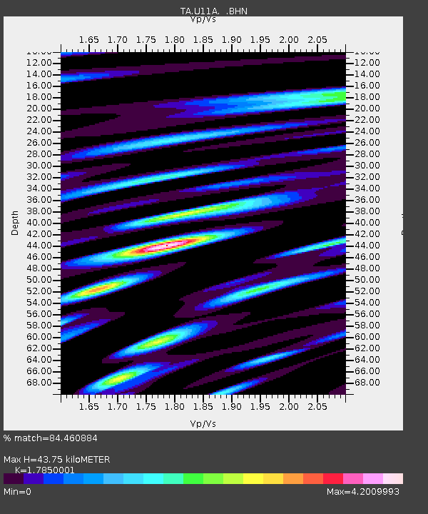
Earthquake location: Andreanof Islands, Aleutian Is.
Earthquake latitude/longitude: 51.4/-179.5
Earthquake time(UTC): 2007/12/19 (353) 09:30:27 GMT
Earthquake Depth: 29 km
Earthquake Magnitude: 6.4 MB, 7.1 MS, 7.1 MW, 7.0 MW
Earthquake Catalog/Contributor: WHDF/NEIC
Network: TA USArray Transportable Network (new EarthScope stations)
Station: U11A Corn Creek, NV, USA
Lat/Lon: 36.42 N/115.38 W
Elevation: 867 m
Distance: 47.1 deg
Az: 82.424 deg
Baz: 309.599 deg
Ray Param: 0.070179865
Estimated Moho Depth: 43.75 km
Estimated Crust Vp/Vs: 1.79
Assumed Crust Vp: 6.276 km/s
Estimated Crust Vs: 3.516 km/s
Estimated Crust Poisson's Ratio: 0.27
Radial Match: 84.460884 %
Radial Bump: 400
Transverse Match: 70.96115 %
Transverse Bump: 400
SOD ConfigId: 2564
Insert Time: 2010-03-06 03:49:55.631 +0000
GWidth: 2.5
Max Bumps: 400
Tol: 0.001

Signal To Noise

ChannelStoNSTALTA
TA:U11A: :BHN:20071219T09:38:25.598013Z2.69691351.3544535E-65.0222354E-7
TA:U11A: :BHE:20071219T09:38:25.598013Z3.94265061.3794872E-63.498883E-7
TA:U11A: :BHZ:20071219T09:38:25.598013Z7.46467642.4907638E-63.3367337E-7
Arrivals
Ps5.8 SECOND
PpPs18 SECOND
PsPs/PpSs24 SECOND