You are here: Home > Network List > TA - USArray Transportable Network (new EarthScope stations) Stations List
> Station U11A Corn Creek, NV, USA > Earthquake Result Viewer
U11A Corn Creek, NV, USA - Earthquake Result Viewer
| Earthquake location: |
South Of Fiji Islands |
| Earthquake latitude/longitude: |
-25.8/179.5 |
| Earthquake time(UTC): |
2007/10/16 (289) 21:05:43 GMT |
| Earthquake Depth: |
509 km |
| Earthquake Magnitude: |
6.2 MB, 6.6 MW, 6.5 MW |
| Earthquake Catalog/Contributor: |
WHDF/NEIC |
|
| Network: |
TA USArray Transportable Network (new EarthScope stations) |
| Station: |
U11A Corn Creek, NV, USA |
| Lat/Lon: |
36.42 N/115.38 W |
| Elevation: |
867 m |
|
| Distance: |
87.1 deg |
| Az: |
47.092 deg |
| Baz: |
234.964 deg |
| Ray Param: |
0.042166788 |
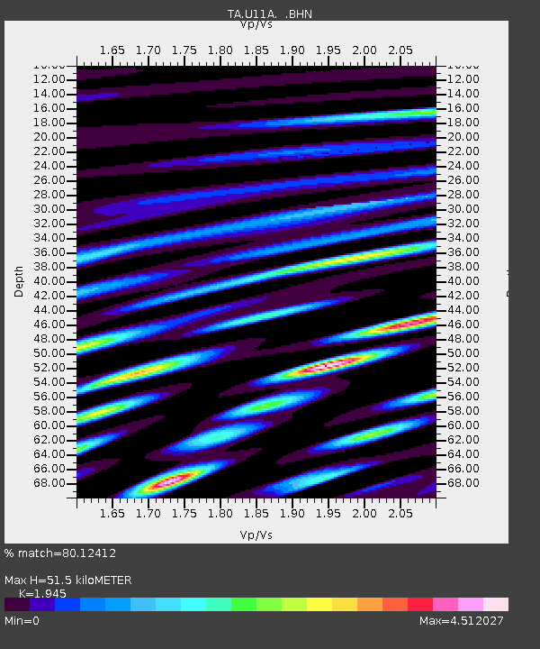
| Estimated Moho Depth: |
51.5 km |
| Estimated Crust Vp/Vs: |
1.95 |
| Assumed Crust Vp: |
6.276 km/s |
| Estimated Crust Vs: |
3.227 km/s |
| Estimated Crust Poisson's Ratio: |
0.32 |
|
| Radial Match: |
80.12412 % |
| Radial Bump: |
400 |
| Transverse Match: |
79.908844 % |
| Transverse Bump: |
360 |
| SOD ConfigId: |
2564 |
| Insert Time: |
2010-03-06 03:50:05.095 +0000 |
| GWidth: |
2.5 |
| Max Bumps: |
400 |
| Tol: |
0.001 |
|

Signal To Noise
| Channel | StoN | STA | LTA |
| TA:U11A: :BHN:20071016T21:17:03.249004Z | 5.5000944 | 1.4743033E-6 | 2.6805054E-7 |
| TA:U11A: :BHE:20071016T21:17:03.249004Z | 10.360906 | 2.2688007E-6 | 2.1897708E-7 |
| TA:U11A: :BHZ:20071016T21:17:03.249004Z | 36.340538 | 4.2986853E-6 | 1.1828899E-7 |
| Arrivals |
| Ps | 7.9 SECOND |
| PpPs | 24 SECOND |
| PsPs/PpSs | 32 SECOND |


