You are here: Home > Network List > TA - USArray Transportable Network (new EarthScope stations) Stations List
> Station U11A Corn Creek, NV, USA > Earthquake Result Viewer
U11A Corn Creek, NV, USA - Earthquake Result Viewer
| Earthquake location: |
Volcano Islands, Japan Region |
| Earthquake latitude/longitude: |
22.0/142.7 |
| Earthquake time(UTC): |
2007/09/28 (271) 13:38:59 GMT |
| Earthquake Depth: |
276 km |
| Earthquake Magnitude: |
6.7 MB, 7.4 MW, 7.4 MW |
| Earthquake Catalog/Contributor: |
WHDF/NEIC |
|
| Network: |
TA USArray Transportable Network (new EarthScope stations) |
| Station: |
U11A Corn Creek, NV, USA |
| Lat/Lon: |
36.42 N/115.38 W |
| Elevation: |
867 m |
|
| Distance: |
86.3 deg |
| Az: |
52.251 deg |
| Baz: |
294.524 deg |
| Ray Param: |
0.043488584 |
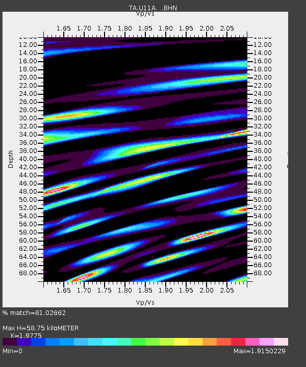
| Estimated Moho Depth: |
58.75 km |
| Estimated Crust Vp/Vs: |
1.98 |
| Assumed Crust Vp: |
6.276 km/s |
| Estimated Crust Vs: |
3.174 km/s |
| Estimated Crust Poisson's Ratio: |
0.33 |
|
| Radial Match: |
81.02662 % |
| Radial Bump: |
400 |
| Transverse Match: |
72.97003 % |
| Transverse Bump: |
400 |
| SOD ConfigId: |
2564 |
| Insert Time: |
2010-03-06 03:50:06.615 +0000 |
| GWidth: |
2.5 |
| Max Bumps: |
400 |
| Tol: |
0.001 |
|

Signal To Noise
| Channel | StoN | STA | LTA |
| TA:U11A: :BHN:20070928T13:50:39.023022Z | 21.986444 | 3.1641537E-6 | 1.4391384E-7 |
| TA:U11A: :BHE:20070928T13:50:39.023022Z | 40.276463 | 6.113936E-6 | 1.5179923E-7 |
| TA:U11A: :BHZ:20070928T13:50:39.023022Z | 121.900955 | 1.3982608E-5 | 1.1470466E-7 |
| Arrivals |
| Ps | 9.3 SECOND |
| PpPs | 27 SECOND |
| PsPs/PpSs | 37 SECOND |


