You are here: Home > Network List > AK - Alaska Regional Network Stations List
> Station GAMB Gambell Broadband > Earthquake Result Viewer
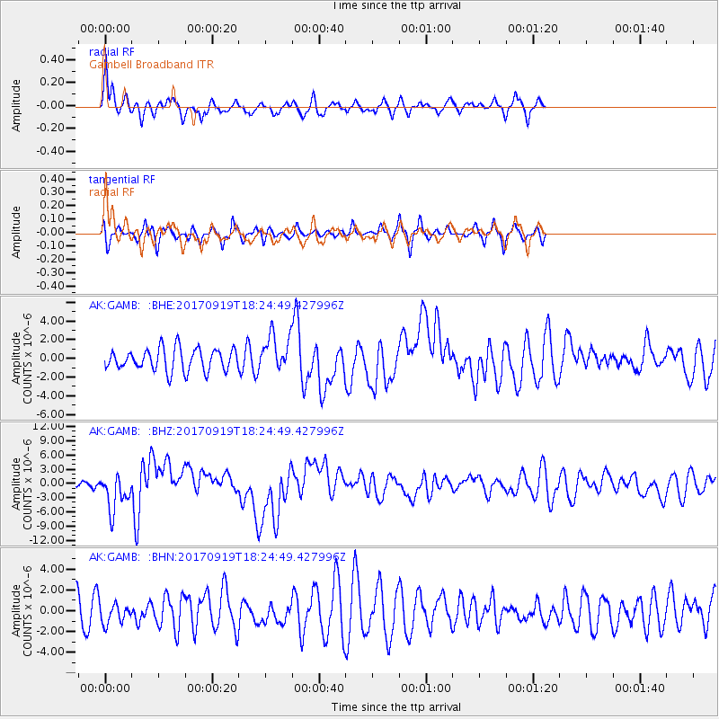
GAMB Gambell Broadband - Earthquake Result Viewer
*The percent match for this event was below the threshold and hence no stack was calculated.
| Earthquake location: |
Central Mexico |
| Earthquake latitude/longitude: |
18.6/-98.5 |
| Earthquake time(UTC): |
2017/09/19 (262) 18:14:38 GMT |
| Earthquake Depth: |
51 km |
| Earthquake Magnitude: |
7.1 Mww |
| Earthquake Catalog/Contributor: |
NEIC PDE/us |
|
| Network: |
AK Alaska Regional Network |
| Station: |
GAMB Gambell Broadband |
| Lat/Lon: |
63.78 N/171.70 W |
| Elevation: |
10 m |
|
| Distance: |
66.1 deg |
| Az: |
332.277 deg |
| Baz: |
96.599 deg |
| Ray Param: |
$rayparam |
*The percent match for this event was below the threshold and hence was not used in the summary stack. |
|
| Radial Match: |
75.9637 % |
| Radial Bump: |
314 |
| Transverse Match: |
61.77041 % |
| Transverse Bump: |
361 |
| SOD ConfigId: |
13570011 |
| Insert Time: |
2019-04-28 19:37:51.716 +0000 |
| GWidth: |
2.5 |
| Max Bumps: |
400 |
| Tol: |
0.001 |
|
Signal To Noise
| Channel | StoN | STA | LTA |
| AK:GAMB: :BHZ:20170919T18:24:49.427996Z | 2.8757515 | 3.8819903E-6 | 1.3499046E-6 |
| AK:GAMB: :BHN:20170919T18:24:49.427996Z | 0.7768331 | 9.177483E-7 | 1.181397E-6 |
| AK:GAMB: :BHE:20170919T18:24:49.427996Z | 1.6473944 | 1.9460285E-6 | 1.1812766E-6 |
| Arrivals |
| Ps | |
| PpPs | |
| PsPs/PpSs | |


