You are here: Home > Network List > TA - USArray Transportable Network (new EarthScope stations) Stations List
> Station U11A Corn Creek, NV, USA > Earthquake Result Viewer
U11A Corn Creek, NV, USA - Earthquake Result Viewer
| Earthquake location: |
Near Coast Of Peru |
| Earthquake latitude/longitude: |
-13.4/-76.6 |
| Earthquake time(UTC): |
2007/08/15 (227) 23:40:57 GMT |
| Earthquake Depth: |
39 km |
| Earthquake Magnitude: |
6.7 MB, 7.9 MS, 8.0 MW, 7.5 ME |
| Earthquake Catalog/Contributor: |
WHDF/NEIC |
|
| Network: |
TA USArray Transportable Network (new EarthScope stations) |
| Station: |
U11A Corn Creek, NV, USA |
| Lat/Lon: |
36.42 N/115.38 W |
| Elevation: |
867 m |
|
| Distance: |
61.6 deg |
| Az: |
324.943 deg |
| Baz: |
136.128 deg |
| Ray Param: |
0.060710166 |
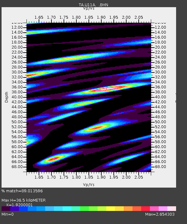
| Estimated Moho Depth: |
36.5 km |
| Estimated Crust Vp/Vs: |
1.92 |
| Assumed Crust Vp: |
6.276 km/s |
| Estimated Crust Vs: |
3.269 km/s |
| Estimated Crust Poisson's Ratio: |
0.31 |
|
| Radial Match: |
89.013596 % |
| Radial Bump: |
400 |
| Transverse Match: |
83.3945 % |
| Transverse Bump: |
400 |
| SOD ConfigId: |
2564 |
| Insert Time: |
2010-03-06 03:50:11.368 +0000 |
| GWidth: |
2.5 |
| Max Bumps: |
400 |
| Tol: |
0.001 |
|

Signal To Noise
| Channel | StoN | STA | LTA |
| TA:U11A: :BHN:20070815T23:50:40.54802Z | 6.4976125 | 9.75344E-7 | 1.5010806E-7 |
| TA:U11A: :BHE:20070815T23:50:40.54802Z | 4.9028187 | 7.729282E-7 | 1.5764977E-7 |
| TA:U11A: :BHZ:20070815T23:50:40.54802Z | 14.000839 | 2.1608614E-6 | 1.54338E-7 |
| Arrivals |
| Ps | 5.6 SECOND |
| PpPs | 16 SECOND |
| PsPs/PpSs | 22 SECOND |


