You are here: Home > Network List > TA - USArray Transportable Network (new EarthScope stations) Stations List
> Station U11A Corn Creek, NV, USA > Earthquake Result Viewer
U11A Corn Creek, NV, USA - Earthquake Result Viewer
| Earthquake location: |
Jujuy Province, Argentina |
| Earthquake latitude/longitude: |
-22.2/-65.8 |
| Earthquake time(UTC): |
2007/07/21 (202) 15:34:52 GMT |
| Earthquake Depth: |
290 km |
| Earthquake Magnitude: |
5.8 MB, 6.4 MW, 6.3 MW |
| Earthquake Catalog/Contributor: |
WHDF/NEIC |
|
| Network: |
TA USArray Transportable Network (new EarthScope stations) |
| Station: |
U11A Corn Creek, NV, USA |
| Lat/Lon: |
36.42 N/115.38 W |
| Elevation: |
867 m |
|
| Distance: |
74.8 deg |
| Az: |
320.455 deg |
| Baz: |
132.961 deg |
| Ray Param: |
0.051316112 |
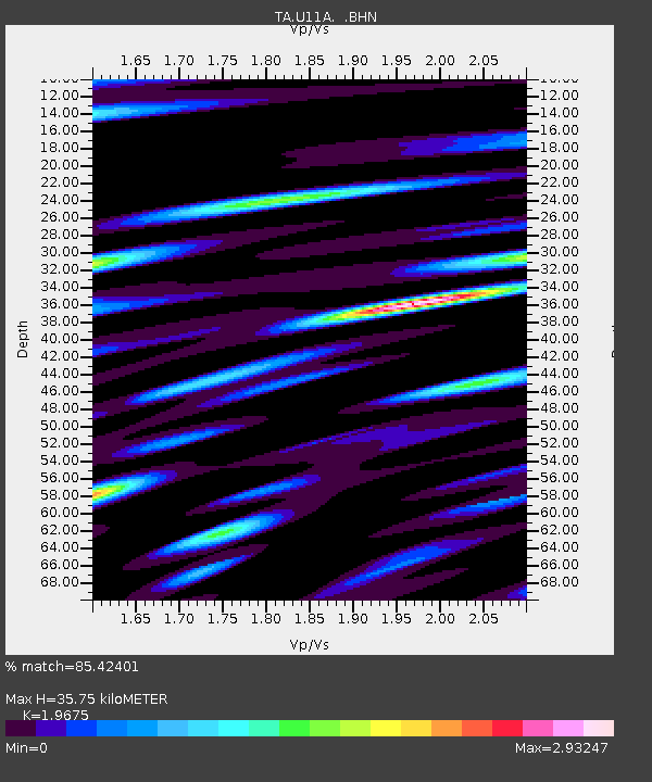
| Estimated Moho Depth: |
35.75 km |
| Estimated Crust Vp/Vs: |
1.97 |
| Assumed Crust Vp: |
6.276 km/s |
| Estimated Crust Vs: |
3.19 km/s |
| Estimated Crust Poisson's Ratio: |
0.33 |
|
| Radial Match: |
85.42401 % |
| Radial Bump: |
400 |
| Transverse Match: |
76.36207 % |
| Transverse Bump: |
400 |
| SOD ConfigId: |
2564 |
| Insert Time: |
2010-03-06 03:50:12.738 +0000 |
| GWidth: |
2.5 |
| Max Bumps: |
400 |
| Tol: |
0.001 |
|

Signal To Noise
| Channel | StoN | STA | LTA |
| TA:U11A: :BHN:20070721T15:45:30.073022Z | 1.4356809 | 1.7854553E-7 | 1.2436296E-7 |
| TA:U11A: :BHE:20070721T15:45:30.073022Z | 1.8973777 | 2.313505E-7 | 1.219317E-7 |
| TA:U11A: :BHZ:20070721T15:45:30.073022Z | 4.233367 | 4.0022246E-7 | 9.4539985E-8 |
| Arrivals |
| Ps | 5.7 SECOND |
| PpPs | 16 SECOND |
| PsPs/PpSs | 22 SECOND |


