You are here: Home > Network List > TA - USArray Transportable Network (new EarthScope stations) Stations List
> Station U11A Corn Creek, NV, USA > Earthquake Result Viewer
U11A Corn Creek, NV, USA - Earthquake Result Viewer
| Earthquake location: |
La Rioja Province, Argentina |
| Earthquake latitude/longitude: |
-28.9/-68.9 |
| Earthquake time(UTC): |
2006/09/12 (255) 13:30:55 GMT |
| Earthquake Depth: |
114 km |
| Earthquake Magnitude: |
5.8 MB, 6.0 MW, 5.9 MW |
| Earthquake Catalog/Contributor: |
WHDF/NEIC |
|
| Network: |
TA USArray Transportable Network (new EarthScope stations) |
| Station: |
U11A Corn Creek, NV, USA |
| Lat/Lon: |
36.42 N/115.38 W |
| Elevation: |
867 m |
|
| Distance: |
78.3 deg |
| Az: |
323.328 deg |
| Baz: |
139.533 deg |
| Ray Param: |
0.049444173 |
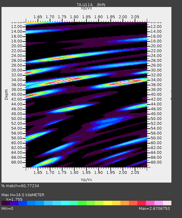
| Estimated Moho Depth: |
34.0 km |
| Estimated Crust Vp/Vs: |
1.75 |
| Assumed Crust Vp: |
6.276 km/s |
| Estimated Crust Vs: |
3.576 km/s |
| Estimated Crust Poisson's Ratio: |
0.26 |
|
| Radial Match: |
80.77234 % |
| Radial Bump: |
400 |
| Transverse Match: |
78.31702 % |
| Transverse Bump: |
400 |
| SOD ConfigId: |
2665 |
| Insert Time: |
2010-03-06 03:50:19.137 +0000 |
| GWidth: |
2.5 |
| Max Bumps: |
400 |
| Tol: |
0.001 |
|

Signal To Noise
| Channel | StoN | STA | LTA |
| TA:U11A: :BHN:20060912T13:42:12.375027Z | 1.37398 | 3.859637E-7 | 2.8090923E-7 |
| TA:U11A: :BHE:20060912T13:42:12.375027Z | 0.6859157 | 2.7023782E-7 | 3.9398108E-7 |
| TA:U11A: :BHZ:20060912T13:42:12.375027Z | 3.349078 | 5.6819766E-7 | 1.6965794E-7 |
| Arrivals |
| Ps | 4.2 SECOND |
| PpPs | 15 SECOND |
| PsPs/PpSs | 19 SECOND |


