You are here: Home > Network List > AV - Alaska Volcano Observatory Stations List
> Station AUCH Augustine Cone H, Augustine Volcano, Alaska > Earthquake Result Viewer
AUCH Augustine Cone H, Augustine Volcano, Alaska - Earthquake Result Viewer
| Earthquake location: |
Central Mexico |
| Earthquake latitude/longitude: |
18.6/-98.5 |
| Earthquake time(UTC): |
2017/09/19 (262) 18:14:38 GMT |
| Earthquake Depth: |
51 km |
| Earthquake Magnitude: |
7.1 Mww |
| Earthquake Catalog/Contributor: |
NEIC PDE/us |
|
| Network: |
AV Alaska Volcano Observatory |
| Station: |
AUCH Augustine Cone H, Augustine Volcano, Alaska |
| Lat/Lon: |
59.36 N/153.44 W |
| Elevation: |
916 m |
|
| Distance: |
56.6 deg |
| Az: |
329.849 deg |
| Baz: |
111.503 deg |
| Ray Param: |
0.063922904 |
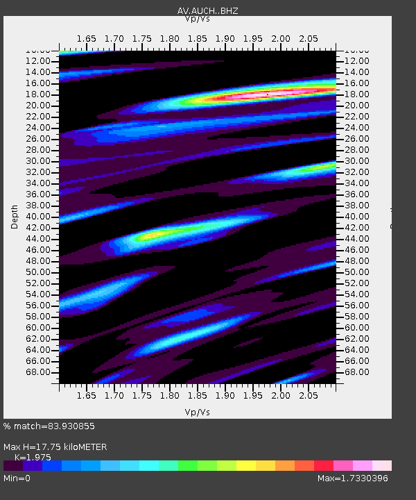
| Estimated Moho Depth: |
17.75 km |
| Estimated Crust Vp/Vs: |
1.98 |
| Assumed Crust Vp: |
5.989 km/s |
| Estimated Crust Vs: |
3.032 km/s |
| Estimated Crust Poisson's Ratio: |
0.33 |
|
| Radial Match: |
83.930855 % |
| Radial Bump: |
400 |
| Transverse Match: |
83.211105 % |
| Transverse Bump: |
400 |
| SOD ConfigId: |
13570011 |
| Insert Time: |
2019-04-28 19:38:58.500 +0000 |
| GWidth: |
2.5 |
| Max Bumps: |
400 |
| Tol: |
0.001 |
|

Signal To Noise
| Channel | StoN | STA | LTA |
| AV:AUCH: :BHZ:20170919T18:23:45.279009Z | 19.492256 | 1.3232975E-5 | 6.7888374E-7 |
| AV:AUCH: :BHN:20170919T18:23:45.279009Z | 2.4065115 | 5.303679E-6 | 2.2038867E-6 |
| AV:AUCH: :BHE:20170919T18:23:45.279009Z | 4.912946 | 8.031702E-6 | 1.6348037E-6 |
| Arrivals |
| Ps | 3.0 SECOND |
| PpPs | 8.5 SECOND |
| PsPs/PpSs | 11 SECOND |


