You are here: Home > Network List > AV - Alaska Volcano Observatory Stations List
> Station AUL Lava Flow, Augustine Volcano, Alaska > Earthquake Result Viewer
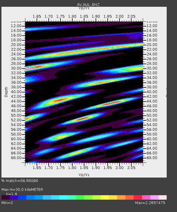
AUL Lava Flow, Augustine Volcano, Alaska - Earthquake Result Viewer
| Earthquake location: |
Central Mexico |
| Earthquake latitude/longitude: |
18.6/-98.5 |
| Earthquake time(UTC): |
2017/09/19 (262) 18:14:38 GMT |
| Earthquake Depth: |
51 km |
| Earthquake Magnitude: |
7.1 Mww |
| Earthquake Catalog/Contributor: |
NEIC PDE/us |
|
| Network: |
AV Alaska Volcano Observatory |
| Station: |
AUL Lava Flow, Augustine Volcano, Alaska |
| Lat/Lon: |
59.38 N/153.44 W |
| Elevation: |
360 m |
|
| Distance: |
56.6 deg |
| Az: |
329.872 deg |
| Baz: |
111.521 deg |
| Ray Param: |
0.063920446 |
| Estimated Moho Depth: |
30.0 km |
| Estimated Crust Vp/Vs: |
1.60 |
| Assumed Crust Vp: |
5.989 km/s |
| Estimated Crust Vs: |
3.743 km/s |
| Estimated Crust Poisson's Ratio: |
0.18 |
|
| Radial Match: |
86.98068 % |
| Radial Bump: |
400 |
| Transverse Match: |
85.801765 % |
| Transverse Bump: |
352 |
| SOD ConfigId: |
13570011 |
| Insert Time: |
2019-04-28 19:38:58.662 +0000 |
| GWidth: |
2.5 |
| Max Bumps: |
400 |
| Tol: |
0.001 |
|

Signal To Noise
| Channel | StoN | STA | LTA |
| AV:AUL: :BHZ:20170919T18:23:45.320024Z | 17.10147 | 7.5793396E-6 | 4.431981E-7 |
| AV:AUL: :BHN:20170919T18:23:45.320024Z | 6.022666 | 4.6397117E-6 | 7.7037504E-7 |
| AV:AUL: :BHE:20170919T18:23:45.320024Z | 2.2572582 | 1.9960255E-6 | 8.842699E-7 |
| Arrivals |
| Ps | 3.2 SECOND |
| PpPs | 12 SECOND |
| PsPs/PpSs | 16 SECOND |


