You are here: Home > Network List > AV - Alaska Volcano Observatory Stations List
> Station AUJA Augustine Junction, Augustine Volcano, Alaska > Earthquake Result Viewer
AUJA Augustine Junction, Augustine Volcano, Alaska - Earthquake Result Viewer
| Earthquake location: |
Central Mexico |
| Earthquake latitude/longitude: |
18.6/-98.5 |
| Earthquake time(UTC): |
2017/09/19 (262) 18:14:38 GMT |
| Earthquake Depth: |
51 km |
| Earthquake Magnitude: |
7.1 Mww |
| Earthquake Catalog/Contributor: |
NEIC PDE/us |
|
| Network: |
AV Alaska Volcano Observatory |
| Station: |
AUJA Augustine Junction, Augustine Volcano, Alaska |
| Lat/Lon: |
59.34 N/153.42 W |
| Elevation: |
376 m |
|
| Distance: |
56.6 deg |
| Az: |
329.828 deg |
| Baz: |
111.51 deg |
| Ray Param: |
0.063935354 |
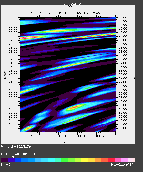
| Estimated Moho Depth: |
20.5 km |
| Estimated Crust Vp/Vs: |
1.62 |
| Assumed Crust Vp: |
5.989 km/s |
| Estimated Crust Vs: |
3.686 km/s |
| Estimated Crust Poisson's Ratio: |
0.20 |
|
| Radial Match: |
85.15276 % |
| Radial Bump: |
400 |
| Transverse Match: |
84.822205 % |
| Transverse Bump: |
400 |
| SOD ConfigId: |
13570011 |
| Insert Time: |
2019-04-28 19:38:59.213 +0000 |
| GWidth: |
2.5 |
| Max Bumps: |
400 |
| Tol: |
0.001 |
|

Signal To Noise
| Channel | StoN | STA | LTA |
| AV:AUJA: :BHZ:20170919T18:23:45.159014Z | 8.50939 | 8.358362E-6 | 9.822515E-7 |
| AV:AUJA: :BHN:20170919T18:23:45.159014Z | 4.8822217 | 5.912936E-6 | 1.2111158E-6 |
| AV:AUJA: :BHE:20170919T18:23:45.159014Z | 4.2063003 | 7.66904E-6 | 1.8232271E-6 |
| Arrivals |
| Ps | 2.2 SECOND |
| PpPs | 8.6 SECOND |
| PsPs/PpSs | 11 SECOND |


