You are here: Home > Network List > AV - Alaska Volcano Observatory Stations List
> Station MCIR Makushin Cirque, Makushin Volcano, Alaska > Earthquake Result Viewer
MCIR Makushin Cirque, Makushin Volcano, Alaska - Earthquake Result Viewer
| Earthquake location: |
Central Mexico |
| Earthquake latitude/longitude: |
18.6/-98.5 |
| Earthquake time(UTC): |
2017/09/19 (262) 18:14:38 GMT |
| Earthquake Depth: |
51 km |
| Earthquake Magnitude: |
7.1 Mww |
| Earthquake Catalog/Contributor: |
NEIC PDE/us |
|
| Network: |
AV Alaska Volcano Observatory |
| Station: |
MCIR Makushin Cirque, Makushin Volcano, Alaska |
| Lat/Lon: |
53.95 N/166.89 W |
| Elevation: |
800 m |
|
| Distance: |
62.5 deg |
| Az: |
321.721 deg |
| Baz: |
96.132 deg |
| Ray Param: |
0.0600645 |
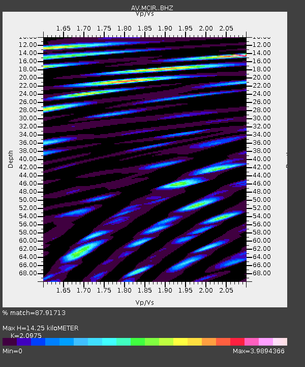
| Estimated Moho Depth: |
14.25 km |
| Estimated Crust Vp/Vs: |
2.10 |
| Assumed Crust Vp: |
3.943 km/s |
| Estimated Crust Vs: |
1.88 km/s |
| Estimated Crust Poisson's Ratio: |
0.35 |
|
| Radial Match: |
87.91713 % |
| Radial Bump: |
400 |
| Transverse Match: |
82.55931 % |
| Transverse Bump: |
400 |
| SOD ConfigId: |
13570011 |
| Insert Time: |
2019-04-28 19:39:07.833 +0000 |
| GWidth: |
2.5 |
| Max Bumps: |
400 |
| Tol: |
0.001 |
|

Signal To Noise
| Channel | StoN | STA | LTA |
| AV:MCIR: :BHZ:20170919T18:24:26.019976Z | 18.404205 | 8.864454E-6 | 4.816537E-7 |
| AV:MCIR: :BHN:20170919T18:24:26.019976Z | 4.6437235 | 3.6965764E-6 | 7.960371E-7 |
| AV:MCIR: :BHE:20170919T18:24:26.019976Z | 8.648247 | 8.733533E-6 | 1.0098616E-6 |
| Arrivals |
| Ps | 4.0 SECOND |
| PpPs | 11 SECOND |
| PsPs/PpSs | 15 SECOND |


