You are here: Home > Network List > AV - Alaska Volcano Observatory Stations List
> Station SPCP Crater Peak Broadband, Mount Spurr, Alaska > Earthquake Result Viewer
SPCP Crater Peak Broadband, Mount Spurr, Alaska - Earthquake Result Viewer
| Earthquake location: |
Central Mexico |
| Earthquake latitude/longitude: |
18.6/-98.5 |
| Earthquake time(UTC): |
2017/09/19 (262) 18:14:38 GMT |
| Earthquake Depth: |
51 km |
| Earthquake Magnitude: |
7.1 Mww |
| Earthquake Catalog/Contributor: |
NEIC PDE/us |
|
| Network: |
AV Alaska Volcano Observatory |
| Station: |
SPCP Crater Peak Broadband, Mount Spurr, Alaska |
| Lat/Lon: |
61.27 N/152.15 W |
| Elevation: |
1616 m |
|
| Distance: |
56.7 deg |
| Az: |
332.254 deg |
| Baz: |
113.944 deg |
| Ray Param: |
0.063827574 |
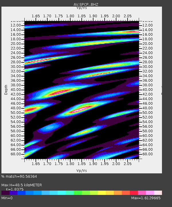
| Estimated Moho Depth: |
48.5 km |
| Estimated Crust Vp/Vs: |
1.84 |
| Assumed Crust Vp: |
6.566 km/s |
| Estimated Crust Vs: |
3.573 km/s |
| Estimated Crust Poisson's Ratio: |
0.29 |
|
| Radial Match: |
90.56364 % |
| Radial Bump: |
400 |
| Transverse Match: |
80.37536 % |
| Transverse Bump: |
400 |
| SOD ConfigId: |
13570011 |
| Insert Time: |
2019-04-28 19:39:20.943 +0000 |
| GWidth: |
2.5 |
| Max Bumps: |
400 |
| Tol: |
0.001 |
|

Signal To Noise
| Channel | StoN | STA | LTA |
| AV:SPCP: :BHZ:20170919T18:23:46.308Z | 39.956146 | 7.434967E-6 | 1.8607817E-7 |
| AV:SPCP: :BHN:20170919T18:23:46.308Z | 20.291718 | 4.5816E-6 | 2.2578669E-7 |
| AV:SPCP: :BHE:20170919T18:23:46.308Z | 20.781551 | 3.9493134E-6 | 1.900394E-7 |
| Arrivals |
| Ps | 6.5 SECOND |
| PpPs | 20 SECOND |
| PsPs/PpSs | 26 SECOND |


