You are here: Home > Network List > C1 - Red Sismologica Nacional Stations List
> Station BO01 Tunca > Earthquake Result Viewer
BO01 Tunca - Earthquake Result Viewer
| Earthquake location: |
Central Mexico |
| Earthquake latitude/longitude: |
18.6/-98.5 |
| Earthquake time(UTC): |
2017/09/19 (262) 18:14:38 GMT |
| Earthquake Depth: |
51 km |
| Earthquake Magnitude: |
7.1 Mww |
| Earthquake Catalog/Contributor: |
NEIC PDE/us |
|
| Network: |
C1 Red Sismologica Nacional |
| Station: |
BO01 Tunca |
| Lat/Lon: |
34.39 S/71.08 W |
| Elevation: |
262 m |
|
| Distance: |
58.8 deg |
| Az: |
153.561 deg |
| Baz: |
329.284 deg |
| Ray Param: |
0.06251557 |
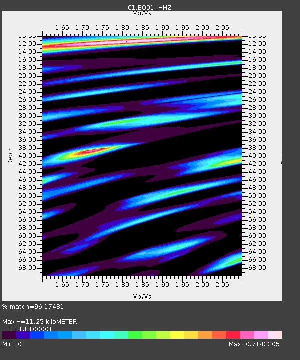
| Estimated Moho Depth: |
11.25 km |
| Estimated Crust Vp/Vs: |
1.81 |
| Assumed Crust Vp: |
6.481 km/s |
| Estimated Crust Vs: |
3.581 km/s |
| Estimated Crust Poisson's Ratio: |
0.28 |
|
| Radial Match: |
96.17481 % |
| Radial Bump: |
400 |
| Transverse Match: |
90.89022 % |
| Transverse Bump: |
400 |
| SOD ConfigId: |
13570011 |
| Insert Time: |
2019-04-28 19:39:49.417 +0000 |
| GWidth: |
2.5 |
| Max Bumps: |
400 |
| Tol: |
0.001 |
|

Signal To Noise
| Channel | StoN | STA | LTA |
| C1:BO01: :HHZ:20170919T18:24:00.599016Z | 20.756033 | 5.4107404E-6 | 2.6068278E-7 |
| C1:BO01: :HHN:20170919T18:24:00.599016Z | 9.328661 | 2.0470898E-6 | 2.1944088E-7 |
| C1:BO01: :HHE:20170919T18:24:00.599016Z | 7.6168003 | 1.3485E-6 | 1.7704285E-7 |
| Arrivals |
| Ps | 1.5 SECOND |
| PpPs | 4.6 SECOND |
| PsPs/PpSs | 6.1 SECOND |


