You are here: Home > Network List > C1 - Red Sismologica Nacional Stations List
> Station LR04 Corral > Earthquake Result Viewer
LR04 Corral - Earthquake Result Viewer
| Earthquake location: |
Central Mexico |
| Earthquake latitude/longitude: |
18.6/-98.5 |
| Earthquake time(UTC): |
2017/09/19 (262) 18:14:38 GMT |
| Earthquake Depth: |
51 km |
| Earthquake Magnitude: |
7.1 Mww |
| Earthquake Catalog/Contributor: |
NEIC PDE/us |
|
| Network: |
C1 Red Sismologica Nacional |
| Station: |
LR04 Corral |
| Lat/Lon: |
39.88 S/73.43 W |
| Elevation: |
94 m |
|
| Distance: |
62.7 deg |
| Az: |
158.467 deg |
| Baz: |
333.096 deg |
| Ray Param: |
0.059968334 |
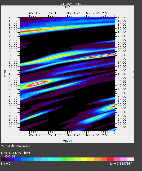
| Estimated Moho Depth: |
44.75 km |
| Estimated Crust Vp/Vs: |
1.69 |
| Assumed Crust Vp: |
6.597 km/s |
| Estimated Crust Vs: |
3.904 km/s |
| Estimated Crust Poisson's Ratio: |
0.23 |
|
| Radial Match: |
90.163284 % |
| Radial Bump: |
210 |
| Transverse Match: |
77.49348 % |
| Transverse Bump: |
400 |
| SOD ConfigId: |
13570011 |
| Insert Time: |
2019-04-28 19:39:58.980 +0000 |
| GWidth: |
2.5 |
| Max Bumps: |
400 |
| Tol: |
0.001 |
|

Signal To Noise
| Channel | StoN | STA | LTA |
| C1:LR04: :HHZ:20170919T18:24:27.079973Z | 8.529263 | 3.870967E-6 | 4.5384544E-7 |
| C1:LR04: :HHN:20170919T18:24:27.079973Z | 5.760994 | 1.878152E-6 | 3.2601181E-7 |
| C1:LR04: :HHE:20170919T18:24:27.079973Z | 2.239206 | 1.0303568E-6 | 4.6014378E-7 |
| Arrivals |
| Ps | 4.9 SECOND |
| PpPs | 17 SECOND |
| PsPs/PpSs | 22 SECOND |


