You are here: Home > Network List > TA - USArray Transportable Network (new EarthScope stations) Stations List
> Station LAVA Lava Cap Winery, Placerville, CA, USA > Earthquake Result Viewer
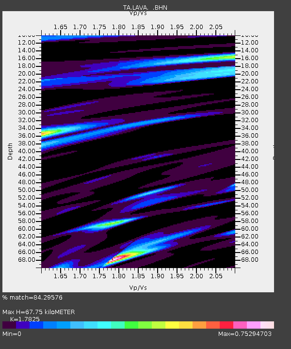
LAVA Lava Cap Winery, Placerville, CA, USA - Earthquake Result Viewer
| Earthquake location: |
Kermadec Islands, New Zealand |
| Earthquake latitude/longitude: |
-30.0/-177.6 |
| Earthquake time(UTC): |
2005/12/07 (341) 23:32:51 GMT |
| Earthquake Depth: |
21 km |
| Earthquake Magnitude: |
6.0 MB, 6.4 MS, 6.4 MW, 6.3 MW |
| Earthquake Catalog/Contributor: |
WHDF/NEIC |
|
| Network: |
TA USArray Transportable Network (new EarthScope stations) |
| Station: |
LAVA Lava Cap Winery, Placerville, CA, USA |
| Lat/Lon: |
38.76 N/120.74 W |
| Elevation: |
828 m |
|
| Distance: |
86.6 deg |
| Az: |
41.007 deg |
| Baz: |
226.711 deg |
| Ray Param: |
0.04394937 |
| Estimated Moho Depth: |
67.75 km |
| Estimated Crust Vp/Vs: |
1.78 |
| Assumed Crust Vp: |
6.597 km/s |
| Estimated Crust Vs: |
3.701 km/s |
| Estimated Crust Poisson's Ratio: |
0.27 |
|
| Radial Match: |
84.29576 % |
| Radial Bump: |
400 |
| Transverse Match: |
72.20545 % |
| Transverse Bump: |
400 |
| SOD ConfigId: |
2564 |
| Insert Time: |
2010-03-06 03:51:02.923 +0000 |
| GWidth: |
2.5 |
| Max Bumps: |
400 |
| Tol: |
0.001 |
|

Signal To Noise
| Channel | StoN | STA | LTA |
| TA:LAVA: :BHN:20051207T23:45:01.550Z | 1.8948389 | 1.7104001E-7 | 9.0266255E-8 |
| TA:LAVA: :BHE:20051207T23:45:01.550Z | 0.8538889 | 1.1957101E-7 | 1.400311E-7 |
| TA:LAVA: :BHZ:20051207T23:45:01.550Z | 4.361168 | 7.1996874E-7 | 1.6508622E-7 |
| Arrivals |
| Ps | 8.2 SECOND |
| PpPs | 28 SECOND |
| PsPs/PpSs | 36 SECOND |


